Fișier:Concord Retreat.png
Mărimea acestei previzualizări: 800 × 342 pixeli. Alte rezoluții: 320 × 137 pixeli | 640 × 273 pixeli | 1.024 × 437 pixeli | 1.280 × 546 pixeli | 3.235 × 1.381 pixeli.
Mărește rezoluția imaginii (3.235 × 1.381 pixeli, mărime fișier: 780 KB, tip MIME: image/png)
| Acest fișier se află la Wikimedia Commons. Consultați pagina sa descriptivă acolo. |
Descriere fișier
| Descriere |
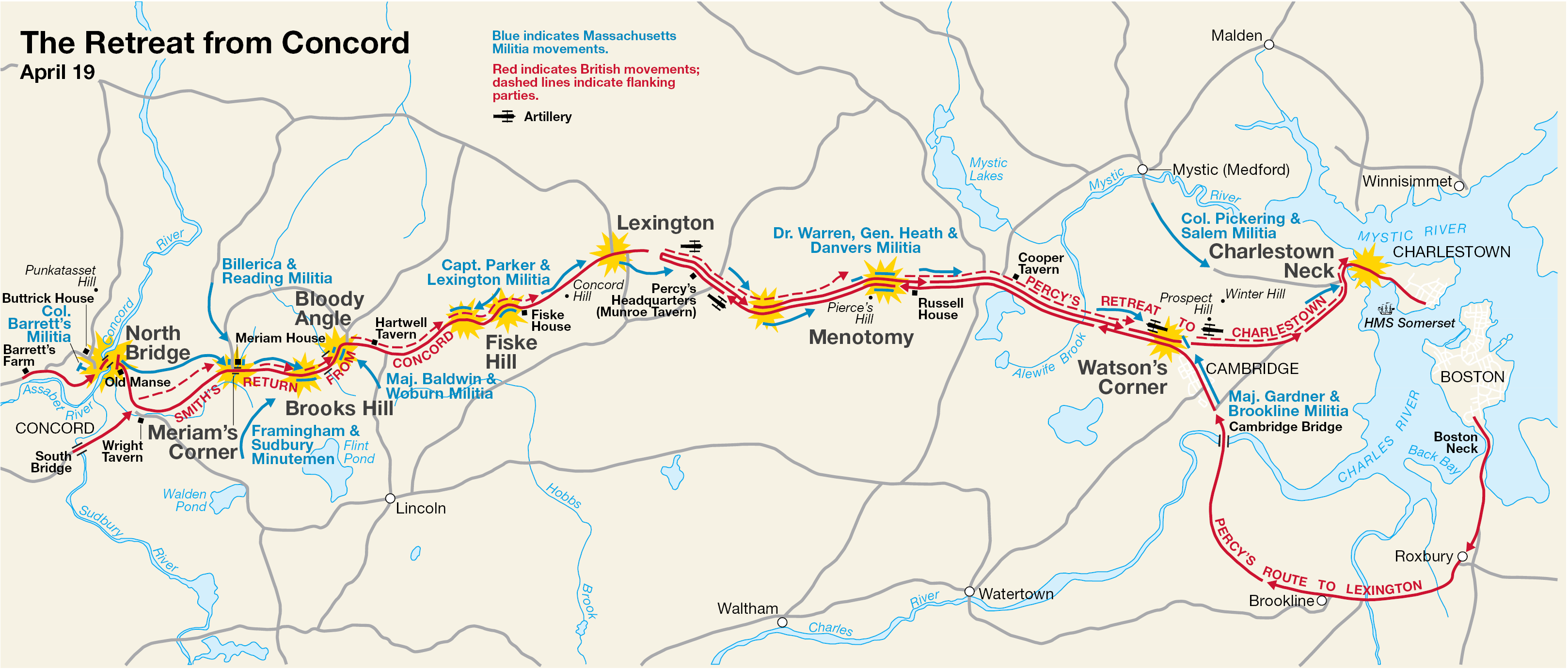
English: This is a map showing the route of the British army's 18-mile retreat from Concord to Charlestown in the Battles of Lexington and Concord on April 19, 1775. It shows the major points of conflict, as well as showing the route taken by Hugh, Earl Percy's reinforcements. |
| Dată | Dată necunoscută; source PDF created in 2000 |
| Sursă | http://data2.itc.nps.gov/parks/mima/ppMaps/MIMAmap2.pdf |
| Autor | National Park Service |
| Alte versiuni |
|

Licențiere
| This image or media file contains material based on a work of a National Park Service employee, created as part of that person's official duties. As a work of the U.S. federal government, such work is in the public domain in the United States. See the NPS website and NPS copyright policy for more information. |
Jurnalul original al încărcărilor
Transferred from en.wikipedia to Commons by Andrei Stroe using CommonsHelper.
Pagina originală de descriere a fost aici. Toate numele de utilizator de mai jos sunt pentru en.wikipedia.
- 2006-11-30 17:35 Irayo 3235×1381× (799048 bytes) The Retreat from Concord April 19 (1775) Minute Man National Historical Park Battle Map http://data2.itc.nps.gov/parks/mima/ppMaps/MIMAmap2.pdf {{PD-USGov-Interior-NPS}}
Istoricul fișierului
Apăsați pe Data și ora pentru a vedea versiunea trimisă atunci.
| Data și ora | Miniatură | Dimensiuni | Utilizator | Comentariu | |
|---|---|---|---|---|---|
| actuală | 29 noiembrie 2010 22:11 | | 3.235x1.381 (780 KB) | File Upload Bot (Magnus Manske) | {{BotMoveToCommons|en.wikipedia|year={{subst:CURRENTYEAR}}|month={{subst:CURRENTMONTHNAME}}|day={{subst:CURRENTDAY}}}} {{Information |Description={{en|This is a map showing the route of the British army's 18-mile retreat from [[:en:Concord, Massachusetts |
Utilizarea fișierului
Următoarele pagini conțin această imagine:
Utilizarea globală a fișierului
Următoarele alte proiecte wiki folosesc acest fișier:
- Utilizare la ar.wikipedia.org
- Utilizare la azb.wikipedia.org
- Utilizare la cs.wikipedia.org
- Utilizare la en.wikipedia.org
- Utilizare la es.wikipedia.org
- Utilizare la fr.wikipedia.org
- Utilizare la it.wikipedia.org
- Utilizare la ru.wikipedia.org
- Utilizare la th.wikipedia.org
- Utilizare la zh.wikipedia.org