Fișier:Geological map Britain William Smith 1815.jpg

Mărește rezoluția imaginii (2.000 × 2.871 pixeli, mărime fișier: 4,63 MB, tip MIME: image/jpeg)
| Acest fișier se află la Wikimedia Commons. Consultați pagina sa descriptivă acolo. |
| Descriere |
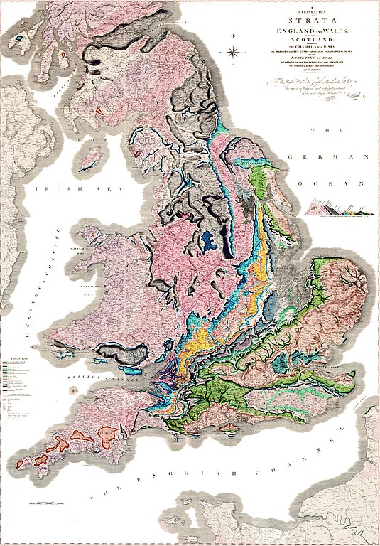
A delineation of the strata of England and Wales with part of Scotland. (The first geological map of Britain, published by William Smith in 1815) |
|||||
| Dată | ||||||
| Sursă |
UNKNOWN العربية: خريطةُ وليام سميث الجيولوجية لإنجلترا وويلز وجنوب اسكتلندا، والتي تم الانتهاء منها في عام 1815م، وتُعتبر ثاني خريطة جيولوجيّة على النطاق الوطني، وكانت أدقَّ خريطةٍ في وقتها |
|||||
| Autor | William Smith (1769-1839) | |||||
| Permisiune (Reutilizarea acestui fișier) |
|
|||||

Istoricul fișierului
Apăsați pe Data și ora pentru a vedea versiunea trimisă atunci.
| Data și ora | Miniatură | Dimensiuni | Utilizator | Comentariu | |
|---|---|---|---|---|---|
| actuală | 20 octombrie 2014 17:45 | | 2.000x2.871 (4,63 MB) | Ivtorov | edited colors, crop. |
| 11 decembrie 2008 03:45 |  | 1.200x1.769 (456 KB) | Gump Stump | {{Information |Description=The first geological map of Britain, published by William Smith in 1815. |Source=[http://www.livescience.com/php/multimedia/imagedisplay/img_display.php?pic=051031_first_map_02.jpg LiveScience Image Gallery] Scan by the Library |
Utilizarea fișierului
Următoarele pagini conțin această imagine:
Utilizarea globală a fișierului
Următoarele alte proiecte wiki folosesc acest fișier:
- Utilizare la ar.wikipedia.org
- Utilizare la bg.wikipedia.org
- Utilizare la bn.wikipedia.org
- Utilizare la ca.wikipedia.org
- Utilizare la de.wikipedia.org
- Utilizare la en.wikipedia.org
- Utilizare la es.wikipedia.org
- Utilizare la fr.wikipedia.org
- Utilizare la fy.wikipedia.org
- Utilizare la gl.wikipedia.org
- Utilizare la he.wikipedia.org
- Utilizare la hy.wikipedia.org
- Utilizare la it.wikipedia.org
- Utilizare la ja.wikipedia.org
- Utilizare la ka.wikipedia.org
Vizualizați utilizările globale ale acestui fișier.