Fișier:NEO lake jau big.jpg

Mărimea acestei previzualizări: 600 × 600 pixeli. Alte rezoluții: 240 × 240 pixeli | 480 × 480 pixeli | 750 × 750 pixeli.
Mărește rezoluția imaginii (750 × 750 pixeli, mărime fișier: 134 KB, tip MIME: image/jpeg)
| Acest fișier se află la Wikimedia Commons. Consultați pagina sa descriptivă acolo. |
Descriere fișier
| Descriere |
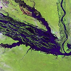
English: The Negro River flowing through the eastern edge of Brazil’s Jau National Park. The river is the big strip of blue running from left to right across the image, and the other blue ribbons are tributaries. Originating at the border of Venezuela and Brazil, the Negro River meets up with the Amazon in central Brazil to become its largest tributary. Half-submerged islands can be seen in the center of the river. Between November and April when the river is at its peak, many of these islands disappear. |
| Dată | |
| Sursă |
http://earthobservatory.nasa.gov/Newsroom/NewImages/images.php3?img_id=10843
|
| Autor | NASA and USGS EROS Data Center Satellite Systems Branch |
Licențiere
This image is in the public domain in the United States because it only contains materials that originally came from the United States Geological Survey, an agency of the United States Department of the Interior. For more information, see the official USGS copyright policy.
|
Jurnalul original al încărcărilor
Pagina originală de descriere a fost aici. Toate numele de utilizator de mai jos sunt pentru en.wikipedia.
- 2003-11-23 05:55 Snoyes 750×750×8 (136760 bytes)
Istoricul fișierului
Apăsați pe Data și ora pentru a vedea versiunea trimisă atunci.
| Data și ora | Miniatură | Dimensiuni | Utilizator | Comentariu | |
|---|---|---|---|---|---|
| actuală | 4 aprilie 2008 23:27 | | 750x750 (134 KB) | File Upload Bot (Magnus Manske) | {{BotMoveToCommons|en.wikipedia}} {{Information |Description={{en|'''Credit(s):''' [http://edc.usgs.gov/ USGS EROS Data Center] Satellite Systems Branch. '''Source:''' http://earthobservatory.nasa.gov/Newsroom/NewImages/images.php3?img_id=10843 ''?The |
Utilizarea fișierului
Următoarele pagini conțin această imagine:
Utilizarea globală a fișierului
Următoarele alte proiecte wiki folosesc acest fișier:
- Utilizare la ar.wikipedia.org
- Utilizare la ast.wikipedia.org
- Utilizare la ba.wikipedia.org
- Utilizare la be.wikipedia.org
- Utilizare la bg.wikipedia.org
- Utilizare la ca.wikipedia.org
- Utilizare la de.wikipedia.org
- Utilizare la de.wikivoyage.org
- Utilizare la en.wikipedia.org
- Utilizare la es.wikipedia.org
- Utilizare la eu.wikipedia.org
- Utilizare la fr.wikipedia.org
- Utilizare la he.wikipedia.org
- Utilizare la he.wikivoyage.org
- Utilizare la hi.wikipedia.org
- Utilizare la hr.wikipedia.org
- Utilizare la id.wikipedia.org
- Utilizare la it.wikivoyage.org
- Utilizare la ja.wikipedia.org
- Utilizare la ka.wikipedia.org
- Utilizare la ko.wikipedia.org
- Utilizare la lt.wikipedia.org
- Utilizare la mai.wikipedia.org
- Utilizare la ml.wikipedia.org
- Utilizare la mt.wikipedia.org
- Utilizare la ne.wikipedia.org
- Utilizare la nl.wikipedia.org
- Utilizare la pl.wikipedia.org
Vizualizați utilizările globale ale acestui fișier.