Fișier:Northern Mali conflict.svg

Mărimea acestei previzualizări PNG a acestui fișier SVG: 629 × 600 pixeli. Alte rezoluții: 252 × 240 pixeli | 503 × 480 pixeli | 805 × 768 pixeli | 1.074 × 1.024 pixeli | 2.148 × 2.048 pixeli | 1.316 × 1.255 pixeli.
Mărește rezoluția imaginii (Fișier SVG, cu dimensiunea nominală de 1.316 × 1.255 pixeli, mărime fișier: 796 KB)
| Acest fișier se află la Wikimedia Commons. Consultați pagina sa descriptivă acolo. |
Descriere fișier
| Descriere |
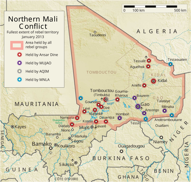
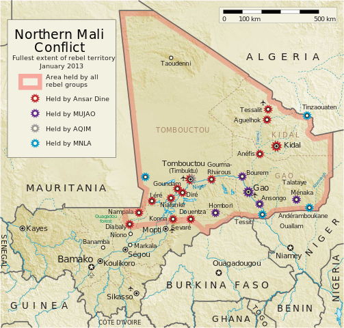
English: Map of the conflict in Northern Mali. (English)
العربية: خريطة الصّراع في شمال مالي. (إنجليزي)
Français : Carte du conflit au nord du Mali. (Anglais)
Latina: Charta rebellionis Tuaregorum in Malia septentrionali. (Anglice)
Українська: Карта конфлікту на півночі Малі. (Англійською) |
| Sursă |
Operă proprie This vector image includes elements that have been taken or adapted from this file: This vector image includes elements that have been taken or adapted from this file: |
| Autor | Orionist |
| Alte versiuni | German/Deutsch/Allemand, French/Français, Macedonian/македонски јазик/Macédonien |
| SVG dezvoltare |
Notes
- ↑ US Department of State, "Country Reports on Terrorism 2011", Chapter 2 Country Reports: Africa Overview, 31 July 2012
Licențiere
Eu, deținătorul drepturilor de autor ale acestei opere, prin prezenta îmi public lucrarea sub următoarea licență:
Acest fișier a fost eliberat sub licența Creative Commons Atribuire și distribuire în condiții identice 3.0 Neadaptată.
- Sunteți liber:
- să partajați cu alții – aveți dreptul de a copia, distribui și transmite opera
- să adaptați – aveți dreptul de a adapta opera
- În următoarele condiții:
- atribuind – Trebuie să atribuiți opera corespunzător, introducând o legătură către licență și indicând dacă ați făcut schimbări. Puteți face asta prin orice metodă rezonabilă, dar nu într-un fel care ar sugera faptul că persoana ce a licențiat conținutul v-ar susține sau ar aproba folosirea de către dumneavoastră a operei sale.
- partajând în condiții identice – Dacă modificați, transformați sau creați pe baza acestei opere, trebuie să distribuiți opera rezultată doar sub aceeași licență sau sub o licență similară acesteia.
Istoricul fișierului
Apăsați pe Data și ora pentru a vedea versiunea trimisă atunci.
| Data și ora | Miniatură | Dimensiuni | Utilizator | Comentariu | |
|---|---|---|---|---|---|
| actuală | 8 aprilie 2014 09:59 | | 1.316x1.255 (796 KB) | Ansh666 | Reverted to version as of 16:51, 8 March 2013 - restoring the correct version, as the map is supposed to be historical, not current |
| 5 decembrie 2013 23:15 |  | 1.316x1.255 (699 KB) | Hanibal911 | more accurately reflects the situation | |
| 8 martie 2013 19:51 |  | 1.316x1.255 (796 KB) | Agricolae | Hombori dot restored | |
| 5 martie 2013 17:29 |  | 1.316x1.255 (794 KB) | TUFKAAP | Since this is an English map, Al-Qaeda in the Islamic Maghreb should be abbreviated as AQIM. | |
| 11 februarie 2013 06:33 |  | 1.316x1.255 (794 KB) | Agricolae | shift text distorted on upload | |
| 11 februarie 2013 06:27 |  | 1.316x1.255 (794 KB) | Agricolae | change to show greatest extent - see WP Talk:Northern Mali conflict (2012–present) | |
| 8 februarie 2013 09:36 |  | 1.316x1.255 (699 KB) | Rama | Aguelhok contested or taken ( http://www.lemonde.fr/afrique/article/2013/02/08/mali-les-forces-francaise-et-tchadiennes-a-aguelhok_1828906_3212.html ) | |
| 2 februarie 2013 13:29 |  | 1.316x1.255 (698 KB) | U5K0 | Bourem to green as per talk page | |
| 30 ianuarie 2013 11:41 |  | 1.316x1.255 (679 KB) | Orionist | Updated map: Menaka, Anderamboukane, Ansongo, Dire, Kidal and other MNLA positions. Removed rebel area boundaries as the situation has become complicated. | |
| 29 ianuarie 2013 20:23 |  | 1.316x1.255 (894 KB) | Jaybear | Insertion of a map-scale in the upper right corner (added directly before the token "/svg" at end of svg-code); |
Utilizarea fișierului
Următoarele pagini conțin această imagine:
Utilizarea globală a fișierului
Următoarele alte proiecte wiki folosesc acest fișier:
- Utilizare la af.wikipedia.org
- Utilizare la ar.wikipedia.org
- Utilizare la azb.wikipedia.org
- Utilizare la az.wikipedia.org
- Utilizare la bg.wikipedia.org
- Utilizare la bn.wikipedia.org
- Utilizare la ca.wikipedia.org
- Utilizare la cs.wikipedia.org
- Utilizare la cy.wikipedia.org
- Utilizare la da.wikipedia.org
- Utilizare la de.wikipedia.org
- Utilizare la el.wikipedia.org
- Utilizare la en.wikipedia.org
- Mali
- Portal:Mali
- Insurgency in the Maghreb (2002–present)
- War on terror
- User:Orionist/Gallery
- National Movement for the Liberation of Azawad
- Wikipedia talk:WikiProject Maps/Archive 2012
- Wikipedia:In the news/Candidates/April 2012
- Wikipedia:Graphics Lab/Map workshop/Archive/Apr 2012
- Wikipedia:Wikipedia Signpost/2012-04-30/WikiProject report
- Wikipedia:Wikipedia Signpost/Single/2012-04-30
- Mali War
- Wikipedia:WikiProject Maps/Conventions/Pushpin maps
- Operation Serval
- Chadian intervention in northern Mali
- Islamist insurgency in the Sahel
- User:AlbanianEditor1990/sandbox
- Utilizare la en.wikinews.org
- Utilizare la eo.wikipedia.org
- Utilizare la es.wikipedia.org
- Utilizare la et.wikipedia.org
- Utilizare la eu.wikipedia.org
- Utilizare la fi.wikipedia.org
Vizualizați utilizările globale ale acestui fișier.