Fișier:Peloponnesian war alliances 431 BC.png
Mărimea acestei previzualizări: 387 × 600 pixeli. Alte rezoluții: 155 × 240 pixeli | 482 × 747 pixeli.
Mărește rezoluția imaginii (482 × 747 pixeli, mărime fișier: 37 KB, tip MIME: image/png)
| Acest fișier se află la Wikimedia Commons. Consultați pagina sa descriptivă acolo. |
Descriere fișier

|
O versiune vectorială a acestei imagini (SVG) este disponibilă.
Aceasta ar trebui folosită în locul vechii imagini pentru o afișare mai bună la rezoluții mari. File:Peloponnesian war alliances 431 BC.png → File:Guerre del Peloponneso 431aC mappa.svg
Pentru mai multe informații despre imaginile vectoriale, consultați pagina Commons transition to SVG. Vedeți, de asemenea, și informațiile despre modul în care software-ul MediaWiki acceptă imagini în format SVG. |
 |
| Descriere |
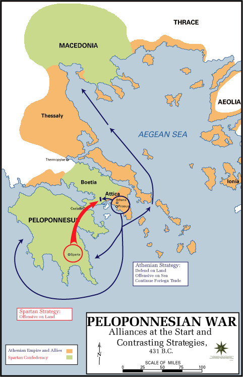
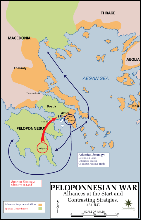
English: The Alliances of the Peloponnesian War |
| Dată | 5 mai 2009 (original upload date) |
| Sursă |
|
| Autor | U.S. Army Cartographer, as amended by uploader to correct spelling mistake |
| Permisiune (Reutilizarea acestui fișier) |
Public domain as a work of the U.S. military.; amendments also released into the public domain |
| Alte versiuni |
|
Licențiere
This work is in the public domain in the United States because it is a work prepared by an officer or employee of the United States Government as part of that person’s official duties under the terms of Title 17, Chapter 1, Section 105 of the US Code.
Note: This only applies to original works of the Federal Government and not to the work of any individual U.S. state, territory, commonwealth, county, municipality, or any other subdivision. This template also does not apply to postage stamp designs published by the United States Postal Service since 1978. (See § 313.6(C)(1) of Compendium of U.S. Copyright Office Practices). It also does not apply to certain US coins; see The US Mint Terms of Use.
|
 | |
| Acest fișier a fost identificat ca fiind liber de orice restricții cunoscute privind legea drepturilor de autor, inclusiv toate drepturile conexe sau înrudite. | ||
Jurnalul original al încărcărilor
Pagina originală de descriere a fost aici. Toate numele de utilizator de mai jos sunt pentru en.wikipedia.
- 2009-05-05 11:43 The Anome 482×747× (34269 bytes) Fixed second spelling mistake, which had been accidentally reinstated by reverting to original source.
- 2009-05-05 11:28 The Anome 482×747× (34263 bytes) {{Information |Description = The Alliances of the Peloponnesian War |Source = http://www.faculty.umb.edu/gary_zabel/Courses/Phil%20281b/Maps/peloponnesian_war_alliances.gif |Date = |Author = U.S. Army Cartographer, as ame
Istoricul fișierului
Apăsați pe Data și ora pentru a vedea versiunea trimisă atunci.
| Data și ora | Miniatură | Dimensiuni | Utilizator | Comentariu | |
|---|---|---|---|---|---|
| actuală | 30 martie 2018 22:35 | | 482x747 (37 KB) | Trecătorul răcit | Gulf of Pella in the time, position of names |
| 5 mai 2009 15:03 |  | 482x747 (33 KB) | File Upload Bot (Magnus Manske) | {{BotMoveToCommons|en.wikipedia|year={{subst:CURRENTYEAR}}|month={{subst:CURRENTMONTHNAME}}|day={{subst:CURRENTDAY}}}} {{Information |Description={{en|The Alliances of the Peloponnesian War}} |Source=Transferred from [http://en.wikipedia.org en.wikipedia |
Utilizarea fișierului
Următoarele pagini conțin această imagine:
Utilizarea globală a fișierului
Următoarele alte proiecte wiki folosesc acest fișier:
- Utilizare la ar.wikipedia.org
- Utilizare la br.wikipedia.org
- Utilizare la ca.wikipedia.org
- Utilizare la da.wikipedia.org
- Utilizare la el.wikipedia.org
- Utilizare la en.wikipedia.org
- Utilizare la et.wikipedia.org
- Utilizare la eu.wikipedia.org
- Utilizare la fa.wikipedia.org
- Utilizare la fi.wikipedia.org
- Utilizare la fr.wikipedia.org
- Utilizare la hyw.wikipedia.org
- Utilizare la id.wikibooks.org
- Utilizare la it.wikipedia.org
- Utilizare la ka.wikipedia.org
- Utilizare la ko.wikipedia.org
- Utilizare la lv.wikipedia.org
- Utilizare la ml.wikipedia.org
- Utilizare la ru.wikipedia.org
- Utilizare la sh.wikipedia.org
- Utilizare la sk.wikipedia.org
- Utilizare la sq.wikipedia.org
- Utilizare la sr.wikipedia.org
- Utilizare la ta.wikipedia.org
- Utilizare la th.wikipedia.org
- Utilizare la tr.wikipedia.org
- Utilizare la vi.wikipedia.org
- Utilizare la xmf.wikipedia.org
- Utilizare la yo.wikipedia.org
- Utilizare la zh-yue.wikipedia.org
- Utilizare la zh.wikipedia.org
- Utilizare la zh.wikibooks.org