Fișier:1866 U.S. Coast Survey Nautical Chart of Charleston Harbor, South Carolina - Geographicus - Charleston-uscs-1866.jpg
Mărește rezoluția imaginii (6.000 × 5.857 pixeli, mărime fișier: 5,87 MB, tip MIME: image/jpeg)
| Acest fișier se află la Wikimedia Commons. Consultați pagina sa descriptivă acolo. |
| Charleston Harbor and its Approaches. | ||||||
|---|---|---|---|---|---|---|
| Artist | ||||||
| Titlu |
Charleston Harbor and its Approaches. |
|||||
| Descriere |
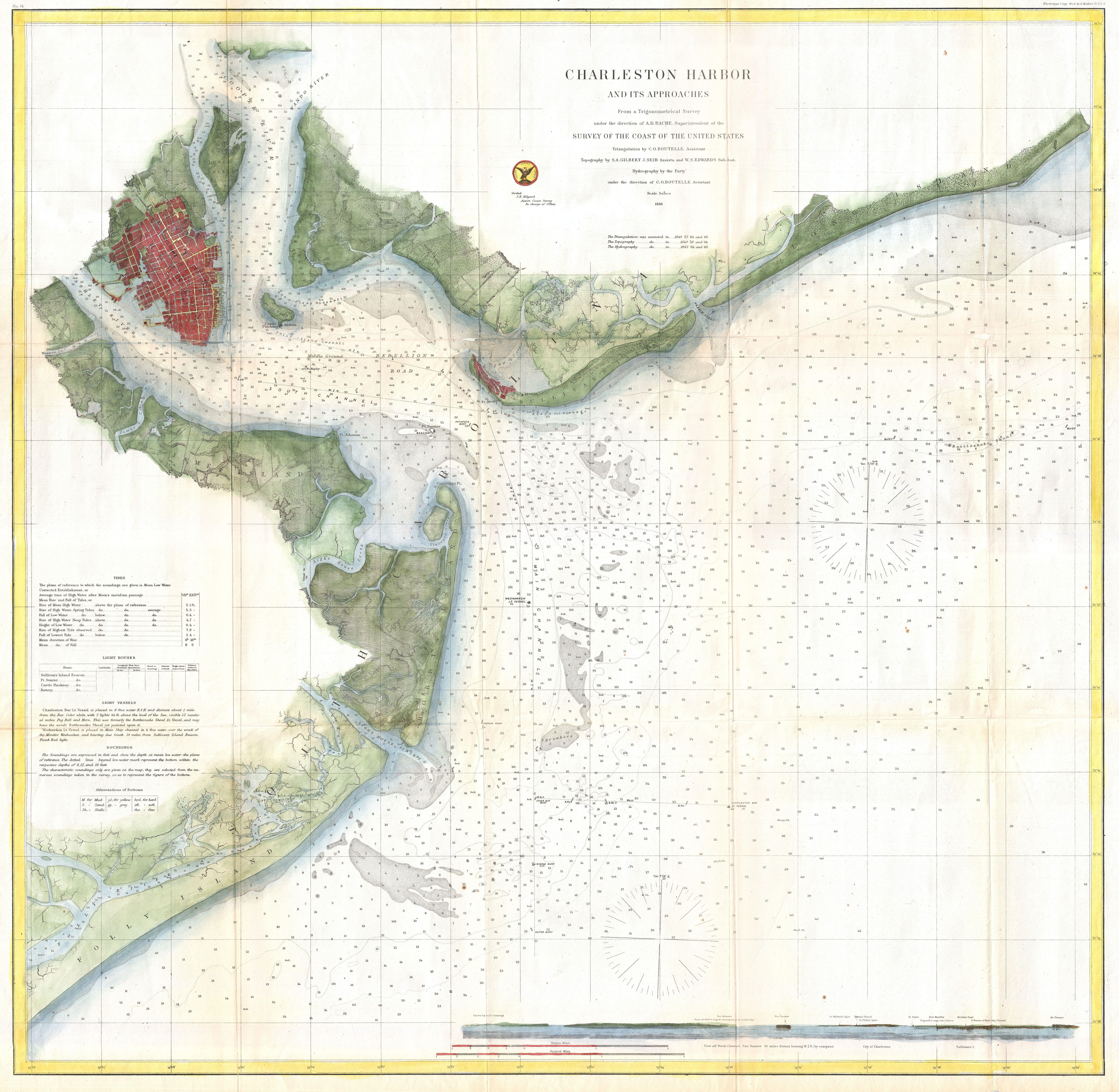
English: This is a highly desirable and uncommon 1866 U.S. Coast Survey chart or map of Charleston Harbor, South Carolina. Covers from Chareston south to Folly Island and east as far as Long island. Offers stunning inland detail identifying roads, farms, landings, and many individual buildings. Shows a detailed street grid for Charleston city noting docks and some commercial buildings. Places Hog Island, Drum Island, Shutes Folly Island, Morris Island, Sullivan’s Island, Long Island and James Island. Nautically this map offers a wealth of practical information for the Mariner, including countless depth soundings and notes on light hoses, tides, shoals, and other undersea dangers. In the lower right quadrant there is a coastal view of North Channel with Fort Sumter. The Triangulation for this chart was completed by C. O. Boutelle. The topography is the work of S. A. Gilbert, J. Seib, and W. S. Edwards. The hydrography was completed by a party under the command of C. O. Boutelle. This chart was compiled under the supervision of A. D. Bache, one of the most influential Superintendents in the history of the Coast Survey. Published in the 1867 supplement to the 1866 edition of the Superintendent's Report . |
|||||
| Dată | 1866 (dated) | |||||
| Dimensiuni | Înălțime: 32 țoli (81,2 cm); lățime: 32 țoli (81,2 cm) | |||||
| Număr de inventar |
Geographicus link: Charleston-uscs-1866 |
|||||
| Sursă/Fotograf |
Report of the Superintendant of the United States Coast Survey, Washington, (1867 Supplement to the 1865 edition).
|
|||||
| Permisiune (Reutilizarea acestui fișier) |
|
|||||
Istoricul fișierului
Apăsați pe Data și ora pentru a vedea versiunea trimisă atunci.
| Data și ora | Miniatură | Dimensiuni | Utilizator | Comentariu | |
|---|---|---|---|---|---|
| actuală | 23 martie 2011 19:38 | | 6.000x5.857 (5,87 MB) | BotMultichillT | {{subst:User:Multichill/Geographicus |link=http://www.geographicus.com/P/AntiqueMap/Charleston-uscs-1866 |product_name=1866 U.S. Coast Survey Nautical Chart of Charleston Harbor, South Carolina |map_title=Charleston Harbor and its Approaches. |description |
Utilizarea fișierului
Următoarele pagini conțin această imagine: