Fișier:Bihać Republic.png

Mărimea acestei previzualizări: 641 × 600 pixeli. Alte rezoluții: 256 × 240 pixeli | 513 × 480 pixeli | 821 × 768 pixeli | 1.076 × 1.007 pixeli.
Mărește rezoluția imaginii (1.076 × 1.007 pixeli, mărime fișier: 131 KB, tip MIME: image/png)
| Acest fișier se află la Wikimedia Commons. Consultați pagina sa descriptivă acolo. |
Descriere fișier
| Descriere |
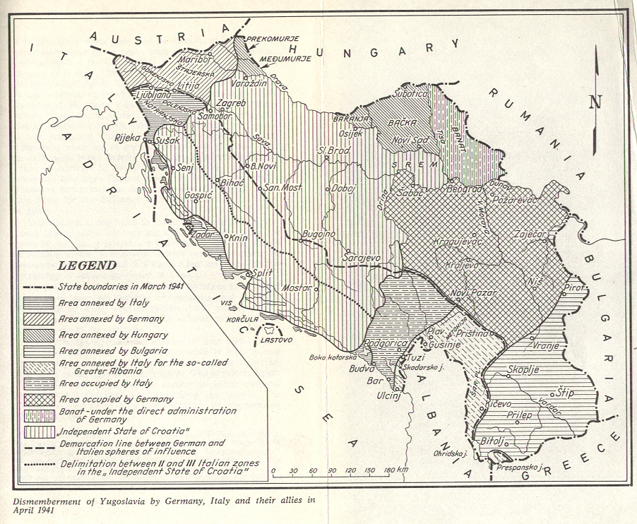
English: Short-lived partisan Republic of Bihać in Yugoslavia during World War II (1942).
Srpskohrvatski / српскохрватски: Kratkotrajna partizanska Bihaćka republika u Jugoslaviji u vreme Drugog svetskog rata (1942). |
| Dată | |
| Sursă | Operă proprie |
| Autor | PANONIAN |
Licențiere
Eu, deținătorul drepturilor de autor ale acestei opere, prin prezenta îmi public lucrarea sub următoarea licență:
| Acest fișier a fost eliberat sub licența Creative Commons CC0 1.0 Universal Public Domain Dedication. | |
| Persoana care a asociat o operă cu acest document o oferă domeniului public, renunțând la toate drepturile asupra operei, în toată lumea, atât în ce privește drepturile de autor cât și orice alte drepturi juridice conexe pe care le avea asupra operei, în măsura permisă de lege. Puteți copia, modifica sau distribui opera, inclusiv în scopuri comerciale, fără a fi necesară permisiunea autorului.
|
References
Borders of the Republic of Bihać are made in accordance with this source:
- Denis Šehić - Demir Šehić, Istorijski atlas sveta, Beograd, 2007.
Borders of Axis partition of Yugoslavia are made in accordance with these sources:
- Istorijski atlas, Geokarta, Beograd, 1999.
- Školski istorijski atlas, Zavod za izdavanje udžbenika SR Srbije, Beograd, 1970.
- Povijesni atlas, Učila - Zagreb, Zagreb, 1971.
- Denis Šehić - Demir Šehić, Istorijski atlas sveta, Beograd, 2007.
- The Times History of Europe, Times Books, London, 2002.
- Richard Overy, The Times History of the 20th Century, Times Books, London, 2004.
- The Times Atlas svjetske povijesti, Cankarjeva založba, Ljubljana - Zagreb, 1986.
- Tim Džuda, Srbi - istorija, mit i razaranje Jugoslavije, Beograd, 2003.
- Džon R. Lempi, Jugoslavija kao istorija, Beograd, 2004.
- Fransisko Veiga, Balkanska zamka (1804-2001), Beograd, 2003.
- Dr Tomislav Bogavac, Nestajanje Srba, Niš, 1994.
- Valter Manošek, Holokaust u Srbiji, Beograd, 2007.
- http://www.terra.es/personal7/jqvaraderey/194145fc.gif
- http://www.svetskirat.net/slike/razbijanje/zazbijanje_jugoslavije_1941.jpg
- http://www.marxists.org/subject/yugoslavia/images/maps/1941-dismemberment.jpg
- http://www.ushmm.org/lcmedia/map/lc/image/yug71020.gif
- http://www.srpska-mreza.com/MAPS/Yugoslavia/YU-Nazi-division.jpg
- http://www.cartoko.com/content/wp-content/uploads/2010/05/Yugoslavia_1992_p038_CtryStudy.jpg[dead link]
- http://www.arhivyu.gov.rs/Data/Images/06_karta_b.jpg archive copy at the Wayback Machine
- http://terkepek.adatbank.transindex.ro/kepek/netre/211.gif
Istoricul fișierului
Apăsați pe Data și ora pentru a vedea versiunea trimisă atunci.
| Data și ora | Miniatură | Dimensiuni | Utilizator | Comentariu | |
|---|---|---|---|---|---|
| actuală | 21 aprilie 2013 18:34 | | 1.076x1.007 (131 KB) | PANONIAN | {{Information |Description=Short-lived partisan Republic of Bihać in Yugoslavia in World War II (in 1942). |Source={{own}} |Date=2013 |Author= PANONIAN |Permission= |other_versions= }} |
Utilizarea fișierului
Următoarele pagini conțin această imagine:
Utilizarea globală a fișierului
Următoarele alte proiecte wiki folosesc acest fișier:
- Utilizare la bg.wikipedia.org
- Utilizare la bs.wikipedia.org
- Utilizare la cs.wikipedia.org
- Utilizare la en.wikipedia.org
- Utilizare la hr.wikipedia.org
- Utilizare la hu.wikipedia.org
- Utilizare la mk.wikipedia.org
- Utilizare la pt.wikipedia.org
- Utilizare la ru.wikipedia.org
- Utilizare la sh.wikipedia.org
- Utilizare la sr.wikipedia.org
- Utilizare la uk.wikipedia.org
- Utilizare la zh.wikipedia.org