Fișier:Circum-Arctic Map of Permafrost and Ground Ice Conditions.png
Mărimea acestei previzualizări: 534 × 599 pixeli. Alte rezoluții: 214 × 240 pixeli | 428 × 480 pixeli | 683 × 766 pixeli.
Mărește rezoluția imaginii (683 × 766 pixeli, mărime fișier: 29 KB, tip MIME: image/png)
| Acest fișier se află la Wikimedia Commons. Consultați pagina sa descriptivă acolo. |

|
Imaginile din această galerie trebuie recreat(ă/e) sub format vectorial ca fișier SVG. Acest format are mai multe avantaje; vezi Commons:Media for cleanup pentru mai multe informații. Dacă deja este disponibilă o versiune SVG a acestei imagini, vă rugăm să o încărcați. După încărcarea pe serverele Commons a versiunii SVG, înlocuiți acest format cu formatul {{vector version available|noul nume al imaginii.svg}}.
|
Descriere fișier
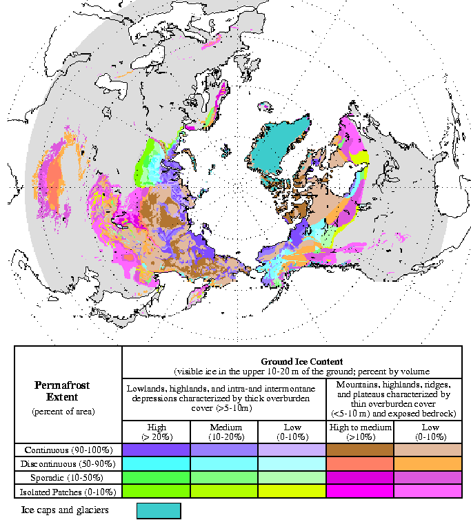
| Descriere | Circum-Arctic Map of Permafrost and Ground Ice Conditions |
| Dată | 1998, revised February 2001 |
| Sursă | http://nsidc.org/data/docs/fgdc/ggd318_map_circumarctic/index.html |
| Autor | Brown, J., O.J. Ferrians, Jr., J.A. Heginbottom, and E.S. Melnikov. 1998, revised February 2001. Circum-arctic map of permafrost and ground ice conditions. Boulder, CO: National Snow and Ice Data Center/World Data Center for Glaciology |
Licențiere
This work is in the public domain in the United States because it is a work prepared by an officer or employee of the United States Government as part of that person’s official duties under the terms of Title 17, Chapter 1, Section 105 of the US Code.
Note: This only applies to original works of the Federal Government and not to the work of any individual U.S. state, territory, commonwealth, county, municipality, or any other subdivision. This template also does not apply to postage stamp designs published by the United States Postal Service since 1978. (See § 313.6(C)(1) of Compendium of U.S. Copyright Office Practices). It also does not apply to certain US coins; see The US Mint Terms of Use.
|
 | |
| Acest fișier a fost identificat ca fiind liber de orice restricții cunoscute privind legea drepturilor de autor, inclusiv toate drepturile conexe sau înrudite. | ||
Istoricul fișierului
Apăsați pe Data și ora pentru a vedea versiunea trimisă atunci.
| Data și ora | Miniatură | Dimensiuni | Utilizator | Comentariu | |
|---|---|---|---|---|---|
| actuală | 23 martie 2015 16:21 | | 683x766 (29 KB) | RokerHRO | optipng -o7 -i0 → 35.32% decrease |
| 21 mai 2008 21:40 |  | 683x766 (44 KB) | Sagredo | {{Information |Description=Circum-Arctic Map of Permafrost and Ground Ice Conditions |Source=http://nsidc.org/data/docs/fgdc/ggd318_map_circumarctic/index.html |Date=1998, revised February 2001 |Author=Brown, J., O.J. Ferrians, Jr., J.A. Heginbottom, and |
Utilizarea fișierului
Următoarele pagini conțin această imagine:
Utilizarea globală a fișierului
Următoarele alte proiecte wiki folosesc acest fișier:
- Utilizare la bxr.wikipedia.org
- Utilizare la ca.wikipedia.org
- Utilizare la ckb.wikipedia.org
- Utilizare la cs.wikipedia.org
- Utilizare la de.wikipedia.org
- Utilizare la el.wikipedia.org
- Utilizare la en.wikipedia.org
- Utilizare la eo.wikipedia.org
- Utilizare la eu.wikipedia.org
- Utilizare la fa.wikipedia.org
- Utilizare la fr.wikipedia.org
- Utilizare la gl.wikipedia.org
- Utilizare la ha.wikipedia.org
- Utilizare la he.wikipedia.org
- ויקיפדיה:ערכים מומלצים/המלצות קודמות/פברואר 2017
- קפאת-עד
- תבנית:ערך מומלץ 19 בפברואר 2017
- תבנית:ערך מומלץ 20 בפברואר 2017
- פורטל:ערכים מומלצים/ערכים/קפאת-עד
- ויקיפדיה:ערכים מומלצים/המלצות קודמות/אפריל 2022
- ויקיפדיה:ערכים מומלצים/המלצות קודמות/פברואר 2024
- תבנית:ערך מומלץ 4 באפריל 2022
- תבנית:ערך מומלץ 14 בפברואר 2024
- Utilizare la hr.wikipedia.org
- Utilizare la id.wikipedia.org
- Utilizare la it.wikipedia.org
- Utilizare la ko.wikipedia.org
- Utilizare la ms.wikipedia.org
- Utilizare la ru.wikipedia.org
- Utilizare la simple.wikipedia.org
- Utilizare la si.wikipedia.org
- Utilizare la sl.wikipedia.org
- Utilizare la sv.wikipedia.org
- Utilizare la tr.wikipedia.org
- Utilizare la uk.wikipedia.org
- Utilizare la zh.wikipedia.org