Fișier:First republic of Armenia-west borders by Woodrow Wilson.png
Rezoluții mai mari nu sunt disponibile.
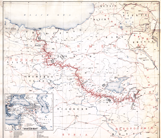
First_republic_of_Armenia-west_borders_by_Woodrow_Wilson.png (558 × 480 pixeli, mărime fișier: 464 KB, tip MIME: image/png)
| Acest fișier se află la Wikimedia Commons. Consultați pagina sa descriptivă acolo. |
Descriere fișier
American memory collection http://hdl.loc.gov/loc.gmd/g7431f.ct000197
hi-res file is available at File:Boundary between Turkey and Armenia as determined by Woodrow Wilson.jpg
Licențiere
This image is in the public domain in the United States because it only contains materials that originally came from the United States Geological Survey, an agency of the United States Department of the Interior. For more information, see the official USGS copyright policy.
|
Istoricul fișierului
Apăsați pe Data și ora pentru a vedea versiunea trimisă atunci.
| Data și ora | Miniatură | Dimensiuni | Utilizator | Comentariu | |
|---|---|---|---|---|---|
| actuală | 4 noiembrie 2007 11:38 | | 558x480 (464 KB) | Rugby471 | shadow & stain |
| 4 noiembrie 2007 10:37 |  | 558x480 (179 KB) | Rugby471 | color | |
| 20 decembrie 2006 01:00 |  | 558x480 (464 KB) | Electionworld | == Summary == American memory collection http://memory.loc.gov/cgi-bin/query/D?gmd:2:./temp/~ammem_He3o::@@@mdb=gmd,ww2map == Licensing == {{PD-USGov}} Category:Maps of the history of Armenia |
Utilizarea fișierului
Următoarele pagini conțin această imagine:
Utilizarea globală a fișierului
Următoarele alte proiecte wiki folosesc acest fișier:
- Utilizare la ar.wikipedia.org
- Utilizare la arz.wikipedia.org
- Utilizare la ast.wikipedia.org
- Utilizare la bg.wikipedia.org
- Utilizare la ca.wikipedia.org
- Utilizare la de.wikipedia.org
- Utilizare la el.wikipedia.org
- Utilizare la en.wikipedia.org
- Utilizare la es.wikipedia.org
- Utilizare la et.wikipedia.org
- Utilizare la fa.wikipedia.org
- Utilizare la fr.wikipedia.org
- Utilizare la he.wikipedia.org
- Utilizare la hr.wikipedia.org
- Utilizare la hy.wikipedia.org
- Utilizare la it.wikipedia.org
- Utilizare la ka.wikipedia.org
- Utilizare la lv.wikipedia.org
- Utilizare la pl.wikipedia.org
- Utilizare la pt.wikipedia.org
- Utilizare la ru.wikipedia.org
Vizualizați utilizările globale ale acestui fișier.