Fișier:Homann Planiglobii Terrestris Cumutroq Hemisphaerio Caelesti Generalis Exhibitio 1707 UTA.jpg

Mărimea acestei previzualizări: 692 × 599 pixeli. Alte rezoluții: 277 × 240 pixeli | 554 × 480 pixeli | 887 × 768 pixeli | 1.182 × 1.024 pixeli | 2.364 × 2.048 pixeli | 3.103 × 2.688 pixeli.
Mărește rezoluția imaginii (3.103 × 2.688 pixeli, mărime fișier: 2,35 MB, tip MIME: image/jpeg)
| Acest fișier se află la Wikimedia Commons. Consultați pagina sa descriptivă acolo. |
Descriere fișier
| Titlu |
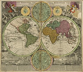
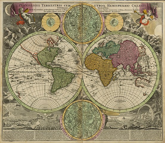
Latina: Planiglobii Terrestris cum Utroq Hemisphaerio Caelesti Generalis Exhibitio... |
||||||||||||||||||||||||||
| Descriere |
English: This double-hemisphere world map features insets of the celestial northern hemisphere and the celestial southern hemisphere, both of which show the mythological figures and objects of the constellations. Windheads and illustrations of a volcanic eruption, earthquake, tides, water-spouts, and a rainbow decorate the four corners of the composition. The map shows California as insular and traces the sailing routes of the explorers Magellan, Olivier van Noort, William Dampier, Abel Tasman, and Juan Gaetano.
Nuremberg cartographer and map publisher Homann and his family later produced a number of celestial and selenographical (lunar) charts in conjunction with the Nuremberg astronomer and mathematician Johann Gabriel Doppelmayr (1677-1750). Many of these charts were featured in Doppelmayr's Atlas coelestis, which Homann's Heirs published in 1742. |
||||||||||||||||||||||||||
| Dată | |||||||||||||||||||||||||||
| Sursă | UTA Libraries Cartographic Connections: hartă / text | ||||||||||||||||||||||||||
| Creator |
|
||||||||||||||||||||||||||
| Modul achiziționării |
English: UTA Libraries Special Collections, Gift of Virginia Garrett |
||||||||||||||||||||||||||
| Georeferencing | If inappropriate please set warp_status = skip to hide. | ||||||||||||||||||||||||||
| Bibliographic data | |||||||||||||||||||||||||||
| Publicație |
Atlas Novus Terrarum Orbis Imperia |
||||||||||||||||||||||||||
| Autor |
|
||||||||||||||||||||||||||
| Locul publicării | Nürnberg | ||||||||||||||||||||||||||
| Editură |
|
||||||||||||||||||||||||||
| Archival data | |||||||||||||||||||||||||||
| Colecție |
|
||||||||||||||||||||||||||
| Dimensiuni | Înălțime: 49 cm; lățime: 57,2 cm | ||||||||||||||||||||||||||
| Mediu | gravură colorată | ||||||||||||||||||||||||||
| artwork-references |
Moreland și Bannister. "Homann Heirs". Error: journal= not stated. Warner, Deborah J. (1979) The Sky Explored: Celestial Cartography 1500-1800, New York City: Alan R. Liss, Inc., p. 120 |
||||||||||||||||||||||||||
.jpg)
Licențiere

|
This file was provided to Wikimedia Commons by the University of Texas at Arlington Libraries as part of a cooperation project. The University of Texas at Arlington Libraries is part of the University of Texas at Arlington, a public research university located in Arlington, Texas.
|
|
Autorul a murit în 1724, astfel încât această lucrare este, de asemenea, în domeniul public în ţările şi zonele în care durata drepturilor de autor este viaţa autorului plus 100 de ani sau mai puţin. Această lucrare este în domeniul public în Statele Unite deoarece a fost publicată înainte de 1 ianuarie 1929. | |
| Acest fișier a fost identificat ca fiind liber de orice restricții cunoscute privind legea drepturilor de autor, inclusiv toate drepturile conexe sau înrudite. | |
Istoricul fișierului
Apăsați pe Data și ora pentru a vedea versiunea trimisă atunci.
| Data și ora | Miniatură | Dimensiuni | Utilizator | Comentariu | |
|---|---|---|---|---|---|
| actuală | 11 februarie 2022 00:22 | | 3.103x2.688 (2,35 MB) | Michael Barera | == {{int:filedesc}} == {{Map |title = {{la|'''''laniglobii Terrestris cum Utroq Hemisphaerio Caelesti Generalis Exhibitio...'''''}} |description = {{en|This double-hemisphere world map features insets of the celestial northern hemisphere and the celestial southern hemisphere, both of which show the mythological figures and objects of the constellations. Windheads and illustrations of a volcanic eruption, earthquake, tides, water-spouts, and a rainbow decorate the four corn... |
Utilizarea fișierului
Următoarele pagini conțin această imagine:
Utilizarea globală a fișierului
Următoarele alte proiecte wiki folosesc acest fișier:
- Utilizare la de.wikipedia.org
- Utilizare la en.wikipedia.org
- Utilizare la es.wikipedia.org
- Utilizare la fa.wikipedia.org
- Utilizare la fr.wikipedia.org
- Utilizare la id.wikipedia.org
- Utilizare la la.wikipedia.org
- Utilizare la nl.wikipedia.org
- Utilizare la pt.wikipedia.org
- Utilizare la ru.wikipedia.org
- Utilizare la sr.wikipedia.org
- Utilizare la sv.wikipedia.org
- Utilizare la uk.wikipedia.org