Fișier:Hooker Map of the State of Coahuila and Texas 1836 UTA.jpg

Mărește rezoluția imaginii (4.122 × 3.436 pixeli, mărime fișier: 11,07 MB, tip MIME: image/jpeg)
| Acest fișier se află la Wikimedia Commons. Consultați pagina sa descriptivă acolo. |
Descriere fișier
| Titlu |
English: Map of the State of Coahuila and Texas |
||||||||||||||||||||||||||
| Descriere |
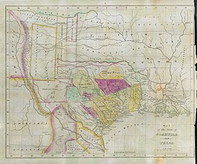
English: Philadelphia engraver, printer, map publisher, and instrument maker William Hooker's Map of Coahuila and Texas first appeared in an 1833 promotional book on Texas by Mary Austin Holley (1784-1846), a first cousin of the famous Texas colonizer Stephen F. Austin. Holley and her first publisher, Armstrong & Plaskitt of Baltimore substituted Hooker's map when Henry S. Tanner, the publisher of Stephen F. Austin's large map of Texas, refused to allow the latter to be used in the book. Both the 1836 map and book have some significant updates from the earlier map and book. Like the map by Hooker that appeared in A Visit to Texas, published by Goodrich & Wiley in New York in 1834, the 1836 map contains all the details of the earlier 1833 version but indirectly also refers to empresarios John McMullen and James McGloin, James Power, John Cameron, other new details such as "Herds of Buffalo" and "Droves of Wild Cattle & Horses" (phrases copied directly from the Austin-Tanner map) and peaks in the west, "Presidio de Rio Grand" [sic], additional towns across the Rio Grande in Chihuahua and Coahuila, the Cross Timbers, Fort Tenoxtitlan, Comanche Indian lands in the west, Cherokee, Creek, and Choctaw Indian lands north of the Red River. In addition, this 1836 map adds other details, such as references to the grants of Juan Antonio Padilla and Thomas Jefferson Chambers in the panhandle (awarded in 1830), and those of John Charles Beale and Dr. James Grant in the west. Further, the map includes the towns of Bastrop, Gonzales, Cole's Settlement (Independence), Montezuma, Orizumba, Columbia, Bell's Landing, and De Leon's colony. The words "now Filisola" are stamped in northeast Texas next to Thorn's Grant – referring to an empresario land grant awarded in 1831 to Italian-born Mexican Army General Vicente Filisola (1789-1850). Handwritten additions in ink on the map are references to Benjamin Milam's grant in the far northeast and the towns of Washington (on the Brazos), Corpus Christi, and [San] Augustine. |
||||||||||||||||||||||||||
| Dată | |||||||||||||||||||||||||||
| Sursă | UTA Libraries Cartographic Connections: hartă / text | ||||||||||||||||||||||||||
| Creator |
|
||||||||||||||||||||||||||
| Modul achiziționării |
English: The University of Texas at Arlington Libraries Special Collections, Gift of Jenkins Garrett |
||||||||||||||||||||||||||
| Geotemporal data | |||||||||||||||||||||||||||
| Map location |
Mexic Texas |
||||||||||||||||||||||||||
| Georeferencing | If inappropriate please set warp_status = skip to hide. | ||||||||||||||||||||||||||
| Bibliographic data | |||||||||||||||||||||||||||
| Publicație |
Texas |
||||||||||||||||||||||||||
| Autor |
|
||||||||||||||||||||||||||
| Pagina | Frontispiece | ||||||||||||||||||||||||||
| Locul publicării | Lexington, Kentucky | ||||||||||||||||||||||||||
| Editură |
J. Clarke & Co. |
||||||||||||||||||||||||||
| Archival data | |||||||||||||||||||||||||||
| Colecție |
|
||||||||||||||||||||||||||
| Dimensiuni | Înălțime: 27 cm; lățime: 34 cm | ||||||||||||||||||||||||||
| Mediu | gravură colorată pe hârtie | ||||||||||||||||||||||||||
| artwork-references |
Huseman, Ben W. (2014) The Price of Manifest Destiny: Maps Relating to the Southwest Borderlands, 1800-1866, Arlington: The University of Texas at Arlington Libraries, p. 16 Streeter, Thomas W. (1983) Bibliography of Texas 1795-1845 (2. ed.), Woodbridge, Connecticut: Research Publications, Inc., pp. 328, 376–377, 383, 397 „Revised and Enlarged by Archibald Hanna with a Guide to the Microfilm Collection. First published by Oxford University Press, 1955.” Davis, Marty, et al (2007) Going to Texas: Five Centuries of Texas Maps, Fort Worth, Texas: Texas Christian University Press, no. 17 , p. 35 Day, James M. (1964) Maps of Texas 1527-1900, Austin: The Pemberton Press, pp. 18, 22 "No. 220" in (2009) Dorothy Sloan Books Auction 22 catalog, Austin |
||||||||||||||||||||||||||
Licențiere

|
This file was provided to Wikimedia Commons by the University of Texas at Arlington Libraries as part of a cooperation project. The University of Texas at Arlington Libraries is part of the University of Texas at Arlington, a public research university located in Arlington, Texas.
|
|
Autorul a murit în 1846, astfel încât această lucrare este, de asemenea, în domeniul public în ţările şi zonele în care durata drepturilor de autor este viaţa autorului plus 100 de ani sau mai puţin. Această lucrare este în domeniul public în Statele Unite deoarece a fost publicată înainte de 1 ianuarie 1929. | |
| Acest fișier a fost identificat ca fiind liber de orice restricții cunoscute privind legea drepturilor de autor, inclusiv toate drepturile conexe sau înrudite. | |
Istoricul fișierului
Apăsați pe Data și ora pentru a vedea versiunea trimisă atunci.
| Data și ora | Miniatură | Dimensiuni | Utilizator | Comentariu | |
|---|---|---|---|---|---|
| actuală | 23 iulie 2019 23:46 | | 4.122x3.436 (11,07 MB) | Michael Barera | ‹== {{int:filedesc}} == {{Map |title = ''Map of the State of Coahuila and Texas'' |description = {{en|Philadelphia engraver, printer, map publisher, and instrument maker William Hooker's ''Map of Coahuila and Texas'' first appeared in an 1833 promotional book on Texas by Mary Austin Holley (1784-1846), a first cousin of the famous Texas colonizer Stephen F. Austin. Holley and her first publisher, Armstrong & Plaskitt of Baltimore substituted Hooker's map when Henry S. Tann... |
Utilizarea fișierului
Următoarele pagini conțin această imagine:
Utilizarea globală a fișierului
Următoarele alte proiecte wiki folosesc acest fișier:
- Utilizare la ca.wikipedia.org
- Utilizare la cs.wikipedia.org
- Utilizare la el.wikipedia.org
- Utilizare la en.wikipedia.org
- Utilizare la es.wikipedia.org
- Utilizare la ja.wikipedia.org
- Utilizare la sv.wikipedia.org