Fișier:North-Carolina-Population-Change-2000-to-2008.png

Mărimea acestei previzualizări: 800 × 303 pixeli. Alte rezoluții: 320 × 121 pixeli | 640 × 243 pixeli | 1.280 × 485 pixeli.
Mărește rezoluția imaginii (1.280 × 485 pixeli, mărime fișier: 208 KB, tip MIME: image/png)
| Acest fișier se află la Wikimedia Commons. Consultați pagina sa descriptivă acolo. |
Descriere fișier
| Descriere |
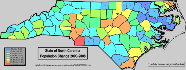
English: Map of North Carolina, using color shading to denote net county-level population change from the 2000 thru 2008 period (2008 population estimates vs. 2000 census values). Data retrieved from https://www.census.gov\/popest/counties/CO-EST2008-02.html Note the large-scale area of net population loss in the inland northeastern part of the state; these counties are all related to each other in that they contain the highest percentage of blacks, according to the Census 2000 data. [1] |
| Dată | |
| Sursă | I created this work entirely by myself. FWIW, though I live in Alabama now, I grew up in Vance County N.C. |
| Autor | Nuberger13 (talk) |
Licențiere
This image or file is a work of a United States Census Bureau employee, taken or made as part of that person's official duties. As a work of the U.S. federal government, the image is in the public domain.
|
 |
Jurnalul original al încărcărilor
Transferred from en.wikipedia to Commons by Magnus Manske using CommonsHelper.
Pagina originală de descriere a fost aici. Toate numele de utilizator de mai jos sunt pentru en.wikipedia.
- 2009-05-02 11:50 Nuberger13 1280×485× (212867 bytes) {{Information |Description = Map of North Carolina, using color shading to denote net county-level population change from the 2000 thru 2008 period (2008 population estimates vs. 2000 census values). Data retrieved from http://www.census.gov/popest/co
Istoricul fișierului
Apăsați pe Data și ora pentru a vedea versiunea trimisă atunci.
| Data și ora | Miniatură | Dimensiuni | Utilizator | Comentariu | |
|---|---|---|---|---|---|
| actuală | 21 februarie 2011 11:41 | 1.280x485 (208 KB) | File Upload Bot (Magnus Manske) | {{BotMoveToCommons|en.wikipedia|year={{subst:CURRENTYEAR}}|month={{subst:CURRENTMONTHNAME}}|day={{subst:CURRENTDAY}}}} {{Information |Description={{en|Map of North Carolina, using color shading to denote net county-level population change from the 2000 t |
Utilizarea fișierului
Următoarele pagini conțin această imagine:
Utilizarea globală a fișierului
Următoarele alte proiecte wiki folosesc acest fișier:
- Utilizare la en.wikipedia.org