Fișier:Operation Dragoon - map.jpg
Mărește rezoluția imaginii (1.265 × 965 pixeli, mărime fișier: 1,94 MB, tip MIME: image/jpeg)
| Acest fișier se află la Wikimedia Commons. Consultați pagina sa descriptivă acolo. |

|
Imaginile din această galerie trebuie recreat(ă/e) sub format vectorial ca fișier SVG. Acest format are mai multe avantaje; vezi Commons:Media for cleanup pentru mai multe informații. Dacă deja este disponibilă o versiune SVG a acestei imagini, vă rugăm să o încărcați. După încărcarea pe serverele Commons a versiunii SVG, înlocuiți acest format cu formatul {{vector version available|noul nume al imaginii.svg}}.
|


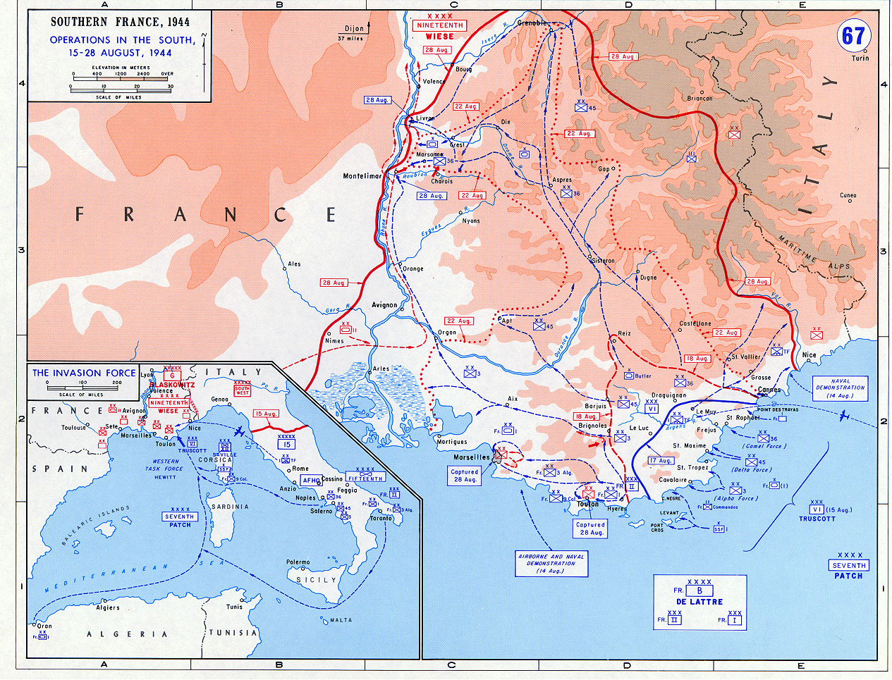
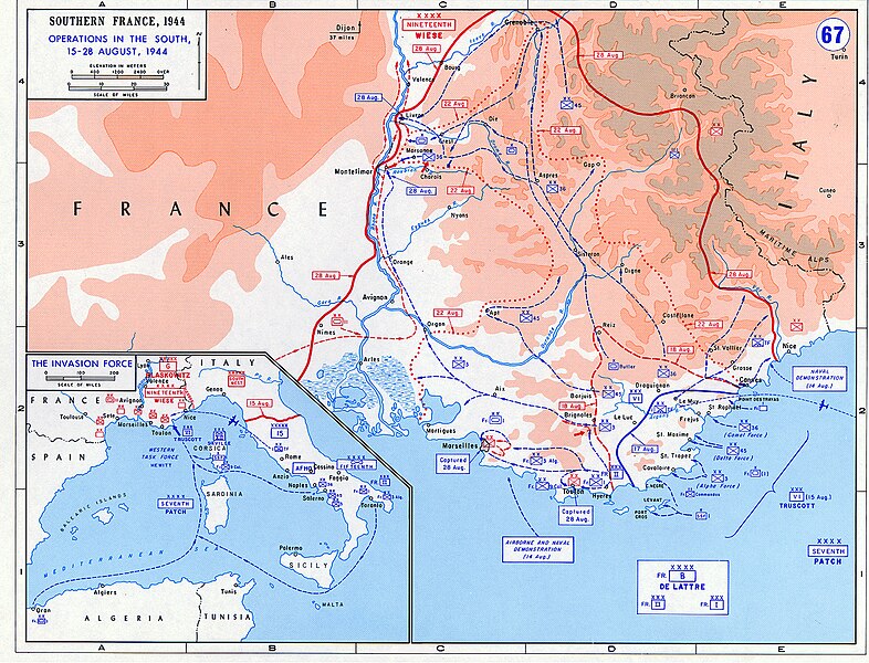
- Description: Operation Dragoon - Aug. 1944
- Source: www.dean.usma.edu
- Background information:
In 1938 the predecessors of what is today The Department of History at the United States Military Academy began developing a series of campaign atlases to aid in teaching cadets a course entitled, "History of the Military Art." Since then, the Department has produced over six atlases and more than one thousand maps, encompassing not only America’s wars but global conflicts as well.
In keeping abreast with today's technology, the Department of History is providing these maps on the internet as part of the department's outreach program. The maps were created by the United States Military Academy’s Department of History and are the digital versions from the atlases printed by the United States Defense Printing Agency. We gratefully acknowledge the accomplishments of the department's former cartographer, Mr. Edward J. Krasnoborski, along with the works of our present cartographer, Mr. Frank Martini.
Please be aware that these maps are large in file size and may require substantial download times.
Notes
- The indication "Dijon 37 miles" in the top middle of the map is most likely an error and should read "Lyon 37 miles".
This file is a work of a U.S. Army soldier or employee, taken or made as part of that person's official duties. As a work of the U.S. federal government, it is in the public domain in the United States.
|
 |
Istoricul fișierului
Apăsați pe Data și ora pentru a vedea versiunea trimisă atunci.
| Data și ora | Miniatură | Dimensiuni | Utilizator | Comentariu | |
|---|---|---|---|---|---|
| actuală | 23 mai 2018 19:50 | | 1.265x965 (1,94 MB) | Hohum | Colour adjust |
| 14 septembrie 2005 20:53 |  | 1.265x965 (1,93 MB) | W.wolny |
Utilizarea fișierului
Următoarele pagini conțin această imagine:
Utilizarea globală a fișierului
Următoarele alte proiecte wiki folosesc acest fișier:
- Utilizare la azb.wikipedia.org
- Utilizare la bg.wikipedia.org
- Utilizare la ca.wikipedia.org
- Utilizare la cs.wikipedia.org
- Utilizare la da.wikipedia.org
- Utilizare la de.wikipedia.org
- Utilizare la el.wikipedia.org
- Utilizare la en.wikipedia.org
- Utilizare la eo.wikipedia.org
- Utilizare la es.wikipedia.org
- Utilizare la fa.wikipedia.org
- Utilizare la fi.wikipedia.org
- Utilizare la fr.wikipedia.org
- Utilizare la he.wikipedia.org
- Utilizare la hu.wikipedia.org
- Utilizare la id.wikipedia.org
- Utilizare la it.wikipedia.org
- Utilizare la ja.wikipedia.org
- Utilizare la ko.wikipedia.org
- Utilizare la nl.wikipedia.org
- Utilizare la no.wikipedia.org
- Utilizare la pl.wikipedia.org
- Utilizare la ru.wikipedia.org
- Utilizare la sh.wikipedia.org
- Utilizare la sk.wikipedia.org
- Utilizare la sl.wikipedia.org
- Utilizare la sv.wikipedia.org
- Utilizare la ta.wikipedia.org
- Utilizare la th.wikipedia.org
- Utilizare la tr.wikipedia.org
- Utilizare la uk.wikipedia.org
- Utilizare la www.wikidata.org
- Utilizare la zh.wikipedia.org