Fișier:PIA23514-Mars-WaterIce-LikeliestAreas-20191210.jpg

Mărește rezoluția imaginii (1.614 × 720 pixeli, mărime fișier: 304 KB, tip MIME: image/jpeg)
| Acest fișier se află la Wikimedia Commons. Consultați pagina sa descriptivă acolo. |
Descriere fișier
| Descriere |
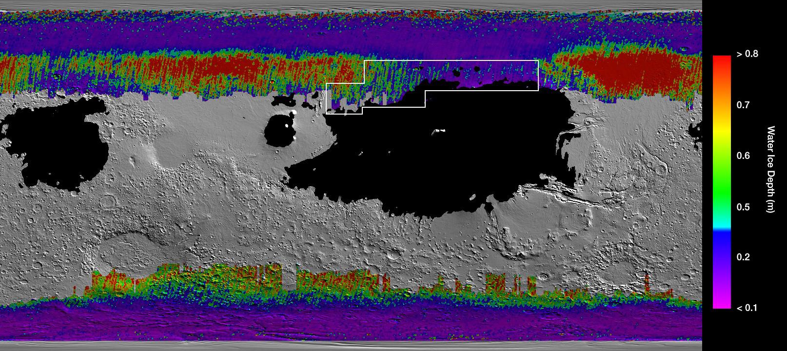
English: A Water Ice Map for Mars
https://www.jpl.nasa.gov/spaceimages/details.php?id=PIA23514 This rainbow-colored map shows underground water ice on Mars. This rainbow-colored map shows underground water ice on Mars. Cool colors represent less than one foot (30 centimeters) below the surface; warm colors are over two feet (60 centimeters) deep. Sprawling black zones on the map represent areas where a landing spacecraft would sink into fine dust. The outlined box represents the ideal region to send astronauts for them to be able to dig up water ice. The map was created by combining data from multiple NASA orbiters, including the Mars Reconnaissance Orbiter and its Mars Climate Sounder instrument; Mars Odyssey and its Thermal Emission Imaging System; and the Mars Global Surveyor. |
| Dată | |
| Sursă | https://photojournal.jpl.nasa.gov/jpeg/PIA23514.jpg |
| Autor | NASA/JPL-Caltech/ASU |
Licențiere
| Acest fişier este în domeniul public fiindcă a fost creat de NASA. Politica drepturilor de autor a NASA spune că „Materialul NASA nu este protejat de dreptul de autor atâta timp cât nu se precizează altfel”. (NASA copyright policy page sau JPL Image Use Policy). | ||
 |
Atenţie:
|
Istoricul fișierului
Apăsați pe Data și ora pentru a vedea versiunea trimisă atunci.
| Data și ora | Miniatură | Dimensiuni | Utilizator | Comentariu | |
|---|---|---|---|---|---|
| actuală | 11 decembrie 2019 03:53 | | 1.614x720 (304 KB) | Drbogdan | User created page with UploadWizard |
Utilizarea fișierului
Următoarele pagini conțin această imagine:
Utilizarea globală a fișierului
Următoarele alte proiecte wiki folosesc acest fișier:
- Utilizare la bn.wikipedia.org
- Utilizare la de.wikipedia.org
- Utilizare la en.wikipedia.org
- Utilizare la zh.wikipedia.org