Fișier:Serbia-WW1-4.jpg
Mărimea acestei previzualizări: 799 × 271 pixeli. Alte rezoluții: 320 × 109 pixeli | 1.023 × 347 pixeli.
Mărește rezoluția imaginii (1.023 × 347 pixeli, mărime fișier: 99 KB, tip MIME: image/jpeg)
| Acest fișier se află la Wikimedia Commons. Consultați pagina sa descriptivă acolo. |

|
This map has been uploaded by Electionworld from en.wikipedia.org to enable the |
Descriere fișier
| Descriere |
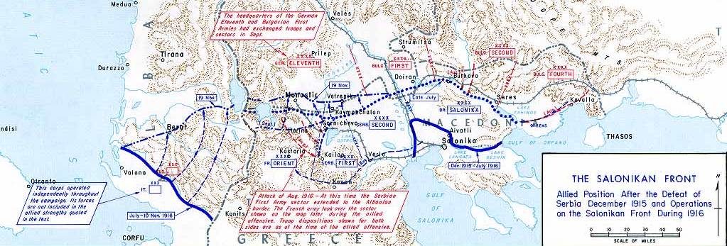
English: Operations at the border of Greece and Serbia, 1916.
his map was created by the Department of Military Art and Engineering, at the U.S. Military Academy (West Point). The initial version was created under the supervision of General Vincent Esposito in 1959. It is now available on the West Point |
||||||
| Dată | |||||||
| Sursă | West Point | ||||||
| Autor | General Vincent Esposito | ||||||
| Permisiune (Reutilizarea acestui fișier) |
|
||||||
| Alte versiuni |
  |
||||||

Istoricul fișierului
Apăsați pe Data și ora pentru a vedea versiunea trimisă atunci.
| Data și ora | Miniatură | Dimensiuni | Utilizator | Comentariu | |
|---|---|---|---|---|---|
| actuală | 22 decembrie 2006 00:55 | 1.023x347 (99 KB) | Electionworld | {{ew|en|Cglassey}} == Summary == Operations at the border of Greece and Serbia, 1916. his map was created by the Department of Military Art and Engineering, at the U.S. Military Academy (West Point). The initial version was created under the supervision |
Utilizarea fișierului
Următoarele pagini conțin această imagine:
Utilizarea globală a fișierului
Următoarele alte proiecte wiki folosesc acest fișier:
- Utilizare la ar.wikipedia.org
- Utilizare la azb.wikipedia.org
- Utilizare la az.wikipedia.org
- Utilizare la be-tarask.wikipedia.org
- Utilizare la be.wikipedia.org
- Utilizare la bg.wikipedia.org
- Utilizare la bs.wikipedia.org
- Utilizare la ca.wikipedia.org
- Utilizare la de.wikipedia.org
- Utilizare la el.wikipedia.org
- Utilizare la en.wikipedia.org
- History of modern Macedonia (Greece)
- Maurice Sarrail
- Macedonian front
- Battle of Doiran (1917)
- Greece during World War I
- Monastir offensive
- Autonomous Province of Korçë
- Bulgarian occupation of Albania
- World War I in Albania
- Battle of the Crna Bend (1917)
- User:GerardM/Battles including the Ottoman Empire
- User:Falcaorib
- User:BoDr12/sandbox
- Utilizare la es.wikipedia.org
- Utilizare la fa.wikipedia.org
- Utilizare la fr.wikipedia.org
- Utilizare la he.wikipedia.org
- Utilizare la hr.wikipedia.org
- Utilizare la hu.wikipedia.org
Vizualizați utilizările globale ale acestui fișier.