Fișier:USA Territorial Growth small.gif
Rezoluții mai mari nu sunt disponibile.
USA_Territorial_Growth_small.gif (431 × 287 pixeli, mărime fișier: 456 KB, tip MIME: image/gif, în buclă, 10 imagini, 30 s)
| Acest fișier se află la Wikimedia Commons. Consultați pagina sa descriptivă acolo. |

|
Acest fișier a fost înlocuit cu File:USA territorial growth.gif. Se recomandă folosirea celuilalt fișier. Notă: Acest fișier nu va fi șters decât prin cererea explicită în cadrul nominalizărilor pentru ștergere.
|

|
Descriere fișier
| Descriere |
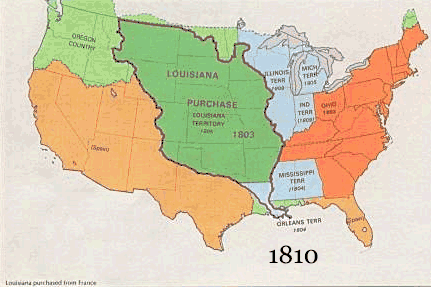
English: US territorial growth 1810–1920, based on the PD USGS maps in Category:Territorial growth maps of the United States.
See key below for explanation of colors.  |
||||||
| Sursă |
|
||||||
| Autor |
|
||||||
| Alte versiuni |
|
Licențiere
This image is in the public domain in the United States because it only contains materials that originally came from the United States Geological Survey, an agency of the United States Department of the Interior. For more information, see the official USGS copyright policy.
|
Istoricul fișierului
Apăsați pe Data și ora pentru a vedea versiunea trimisă atunci.
| Data și ora | Miniatură | Dimensiuni | Utilizator | Comentariu | |
|---|---|---|---|---|---|
| actuală | 30 mai 2006 13:50 | | 431x287 (456 KB) | Roke~commonswiki | US territorial growth, based on the PD USGS maps in Category:USA Territorial Growth Maps Category: USA Territorial Growth Maps {{PD-USGov-USGS}} |
Utilizarea fișierului
Următoarele pagini conțin această imagine:
Utilizarea globală a fișierului
Următoarele alte proiecte wiki folosesc acest fișier:
- Utilizare la ar.wikipedia.org
- Utilizare la be-tarask.wikipedia.org
- Utilizare la be.wikipedia.org
- Utilizare la ca.wikipedia.org
- Utilizare la ckb.wikipedia.org
- Utilizare la da.wikipedia.org
- Utilizare la fr.wikipedia.org
- Utilizare la fy.wikipedia.org
- Utilizare la gcr.wikipedia.org
- Utilizare la hr.wikipedia.org
- Utilizare la id.wikipedia.org
- Utilizare la it.wikipedia.org
- Utilizare la jv.wikipedia.org
- Utilizare la kk.wikipedia.org
- Utilizare la sh.wikipedia.org
- Utilizare la sl.wikipedia.org
- Utilizare la sr.wikipedia.org
- Utilizare la tr.wikipedia.org
- Utilizare la uk.wikipedia.org