Fișier:US Navy 110318-N-0076O-004 An aerial view of damage to northern Honshu, Japan, after a 9.0 magnitude earthquake and subsequent tsunami devastated t.jpg
Mărimea acestei previzualizări: 800 × 532 pixeli. Alte rezoluții: 320 × 213 pixeli | 640 × 426 pixeli | 1.024 × 681 pixeli | 1.280 × 852 pixeli | 2.560 × 1.704 pixeli | 4.592 × 3.056 pixeli.
Mărește rezoluția imaginii (4.592 × 3.056 pixeli, mărime fișier: 3,81 MB, tip MIME: image/jpeg)
| Acest fișier se află la Wikimedia Commons. Consultați pagina sa descriptivă acolo. |
Descriere fișier
| Descriere |
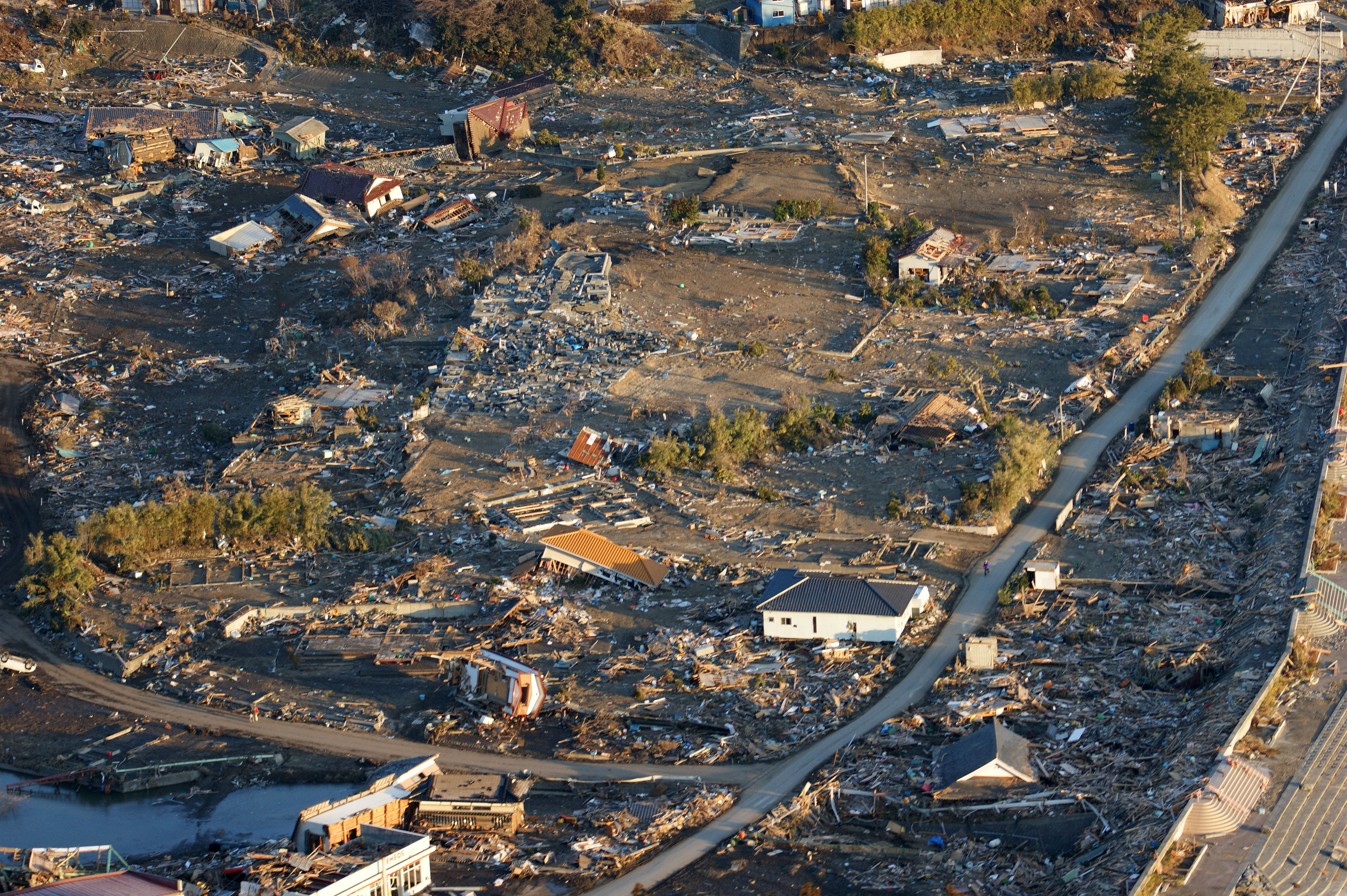
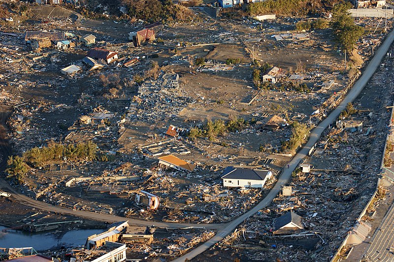
English: (March 18, 2011) An aerial view of damage to northern Honshu, Japan, after a 9.0 magnitude earthquake and subsequent tsunami devastated the area. (U.S. Navy photo by Naval Air Crewman 1st Class Jay Okonek/Released)
Hanagai, Hirotachō, Rikuzentakata city, Iwate prefecture, Japan. 日本語: 2011年3月18日。マグニチュード 9.0 の地震およびそれに続く津波に襲われた後の被害を伝える空撮。(写真:米海軍航空隊一等兵ジェイ・オコネク) 岩手県陸前高田市広田町花貝付近。 |
|||
| Dată | Taken on 18 martie 2011 | |||
| Sursă |
|
|||
| Autor | U.S. Navy photo by Naval Air Crewman 1st Class Jay Okonek |

| Poziția obiectului | | Vizualizați poziția acestei și a altor imagini la: OpenStreetMap |
|---|
Licențiere
This file is a work of a sailor or employee of the U.S. Navy, taken or made as part of that person's official duties. As a work of the U.S. federal government, it is in the public domain in the United States.
|
 | |
| Acest fișier a fost identificat ca fiind liber de orice restricții cunoscute privind legea drepturilor de autor, inclusiv toate drepturile conexe sau înrudite. | ||
Istoricul fișierului
Apăsați pe Data și ora pentru a vedea versiunea trimisă atunci.
| Data și ora | Miniatură | Dimensiuni | Utilizator | Comentariu | |
|---|---|---|---|---|---|
| actuală | 19 martie 2011 05:07 | | 4.592x3.056 (3,81 MB) | BotMultichillT | == {{int:filedesc}} == {{Information |description={{en|1=NORTH HONSHU, Japan (March 18, 2011) An aerial view of damage to northern Honshu, Japan, after a 9.0 magnitude earthquake and subsequent tsunami devastated the area. (U.S. Navy photo by Naval Air Cr |
Utilizarea fișierului
Următoarele pagini conțin această imagine:
Utilizarea globală a fișierului
Următoarele alte proiecte wiki folosesc acest fișier:
- Utilizare la en.wikipedia.org
- Utilizare la es.wikinews.org
- Fuerte sismo de 9.0 grados estremece a Japón, alerta de tsunami
- Chile monitorea sus costas en tiempo real por el tsunami en Japón
- Más de mil muertos en Japón por terremoto y tsunami, 100.000 desaparecidos
- Plantilla:Terremoto en Japón de 2011
- Volcán Karangetang en Indonesia entra en erupción por terremoto en Japón
- Fuerte oleaje en las Islas Galápagos luego del terremoto en Japón, no hay daños
- Cancelada alerta de tsunami para todo el Pacífico tras terremoto en Japón
- Japón sufre el peor desastre nuclear desde la catástrofe de Chernóbil
- Cuatro centrales nucleares en Japón se encuentran dañadas por el terremoto
- Autoridades japonesas hallan 2 mil cadáveres en la prefectura de Miyagi
- Gobierno de Japón confirma tres mil muertos por el terremoto y tsunami
- Japón enfrenta crisis nuclear y humanitaria a una semana del sismo
- Un respiro para Japón; fuga radioactiva hacia el océano fue sellada
- Fuerte sismo mata a dos personas y hiere a otras 100 en Japón
- Nuevo terremoto en Japón dañó otra central nuclear
- Aumentan el nivel de alerta radioactiva en la central nuclear Fukushima
- Japón jugará la Copa América 2011
- Primer ministro japonés ordena el cierre de central nuclear en el centro de Japón
- Japón realiza más de 360.000 pruebas a niños en Prefectura de Fukushima
- Nueva fuga de agua radioactiva de la central Fukushima escapa al Océano Pacífico
- El Ministro de Ambiente de Japón insta a ayudar a eliminar los escombros del desastre de Tōhoku
- Usuario:Jorge Abellán/Taller/Tema/Data
- Utilizare la ko.wikipedia.org
- Utilizare la ru.wikinews.org
- Utilizare la vi.wikipedia.org
- Utilizare la zh-yue.wikipedia.org