Fișier:Volcan-de-Fuego-v2.jpg
Mărește rezoluția imaginii (5.288 × 3.000 pixeli, mărime fișier: 3,39 MB, tip MIME: image/jpeg)
| Acest fișier se află la Wikimedia Commons. Consultați pagina sa descriptivă acolo. |
Descriere fișier
| Descriere |
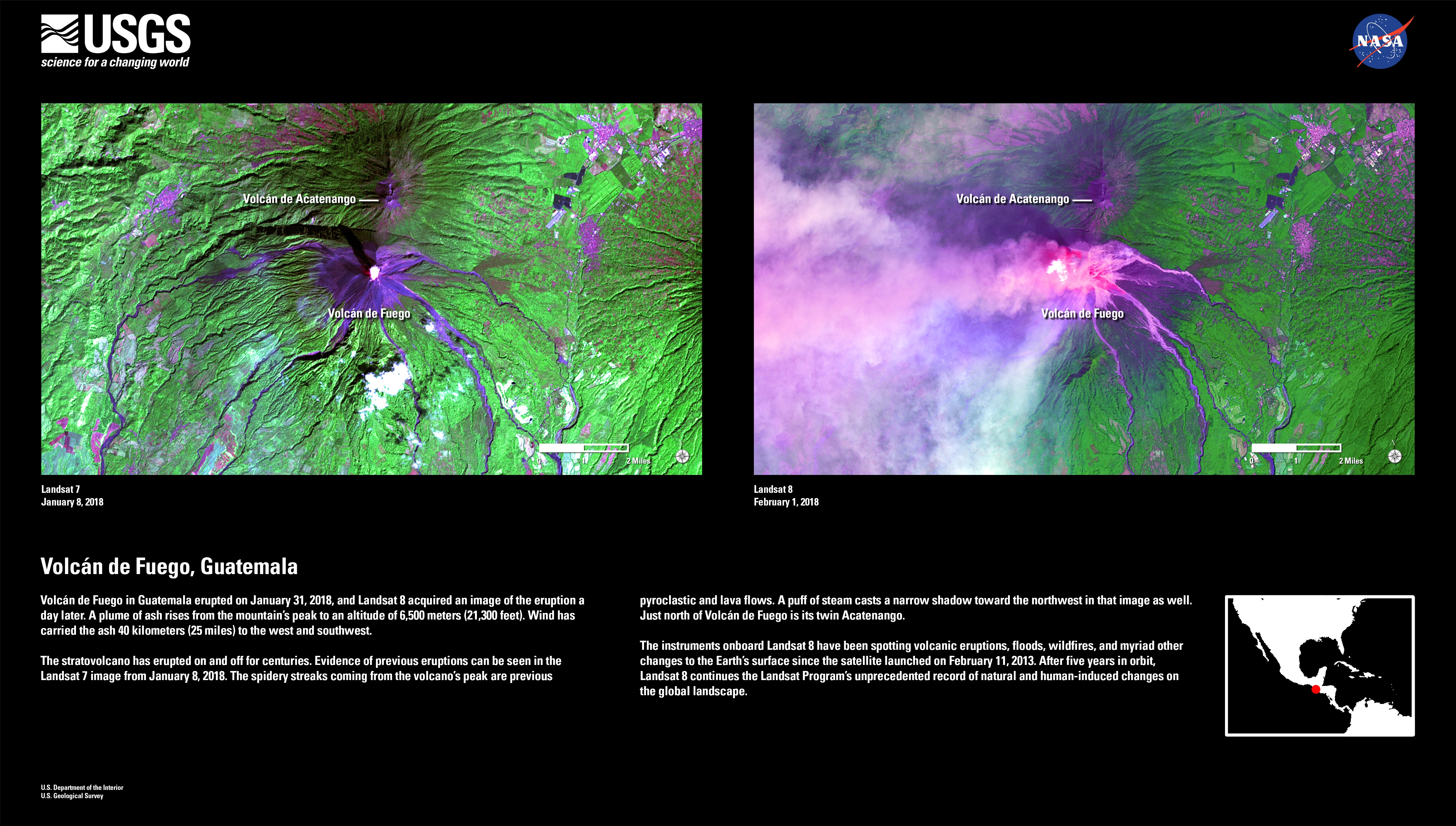
English: Volcán de Fuego in Guatemala erupted on January 31, 2018, and Landsat 8 acquired an image of the eruption a day later. A plume of ash rises from the mountain’s peak to an altitude of 6,500 meters (21,300 feet). Wind has carried the ash 40 kilometers (25 miles) to the west and southwest.
The stratovolcano has erupted on and off for centuries. Evidence of previous eruptions can be seen in the Landsat 7 image from January 8, 2018. The spidery streaks coming from the volcano’s peak are previous pyroclastic and lava flows. A puff of steam casts a narrow shadow toward the northwest in that image as well. Just north of Volcán de Fuego is its twin Acatenango. The instruments onboard Landsat 8 have been spotting volcanic eruptions, floods, wildfires, and myriad other changes to the Earth’s surface since the satellite launched on February 11, 2013. After five years in orbit, Landsat 8 continues the Landsat Program’s unprecedented record of natural and human-induced changes on the global landscape. |
| Dată | |
| Sursă |
Volcán de Fuego in Guatemala erupted on January 31, 2018, and Landsat 8 acquired an image of the eruption a day later. A plume of ash rises from the mountain’s peak to an altitude of 6,500 meters (21,300 feet). Wind has carried the ash 40 kilometers (25 miles) to the west and southwest. The stratovolcano has erupted on and off for centuries. Evidence of previous eruptions can be seen in the Landsat 7 image from January 8, 2018. The spidery streaks coming from the volcano’s peak are previous pyroclastic and lava flows. A puff of steam casts a narrow shadow toward the northwest in that image as well. Just north of Volcán de Fuego is its twin Acatenango. The instruments onboard Landsat 8 have been spotting volcanic eruptions, floods, wildfires, and myriad other changes to the Earth’s surface since the satellite launched on February 11, 2013. After five years in orbit, Landsat 8 continues the Landsat Program’s unprecedented record of natural and human-induced changes on the global landscape. |
| Autor | U.S. Department of the Interior | U.S. Geological Survey |
Licențiere
This image is in the public domain in the United States because it only contains materials that originally came from the United States Geological Survey, an agency of the United States Department of the Interior. For more information, see the official USGS copyright policy.
|
Istoricul fișierului
Apăsați pe Data și ora pentru a vedea versiunea trimisă atunci.
| Data și ora | Miniatură | Dimensiuni | Utilizator | Comentariu | |
|---|---|---|---|---|---|
| actuală | 6 iunie 2018 13:50 | | 5.288x3.000 (3,39 MB) | LuisArmandoRasteletti | User created page with UploadWizard |
Utilizarea fișierului
Următoarele pagini conțin această imagine:
Utilizarea globală a fișierului
Următoarele alte proiecte wiki folosesc acest fișier:
- Utilizare la ast.wikipedia.org
- Utilizare la es.wikipedia.org