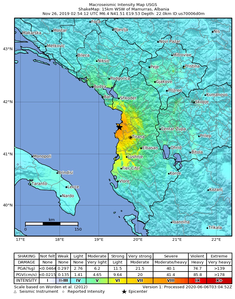
Fișier:2019-11-26 Mamurras, Albania M6.4 earthquake shakemap (USGS).jpg
Mărimea acestei previzualizări: 471 × 600 pixeli. Alte rezoluții: 188 × 240 pixeli | 377 × 480 pixeli | 786 × 1.001 pixeli.
Mărește rezoluția imaginii (786 × 1.001 pixeli, mărime fișier: 388 KB, tip MIME: image/jpeg)
| Acest fișier se află la Wikimedia Commons. Consultați pagina sa descriptivă acolo. |
.jpg)
Descriere fișier
| Descriere | |
| Dată | |
| Sursă | https://earthquake.usgs.gov/earthquakes/eventpage/us70006d0m |
| Autor | Serviciul de prospectare geologică al Statelor Unite |
Licențiere
This image is in the public domain in the United States because it only contains materials that originally came from the United States Geological Survey, an agency of the United States Department of the Interior. For more information, see the official USGS copyright policy.
|
Istoricul fișierului
Apăsați pe Data și ora pentru a vedea versiunea trimisă atunci.
| Data și ora | Miniatură | Dimensiuni | Utilizator | Comentariu | |
|---|---|---|---|---|---|
| actuală | 2 septembrie 2020 14:34 | | 786x1.001 (388 KB) | IllCom | New Version by USGS |
| 19 decembrie 2019 03:04 |  | 799x1.027 (384 KB) | Cewbot | Import USGS updated earthquake map, shakemap id: urn:usgs-product:us:shakemap:us70006d0m:1576710484988 (2019-12-18T23:08:04.988Z) | |
| 28 noiembrie 2019 09:03 |  | 799x1.027 (384 KB) | Cewbot | Import USGS updated earthquake map, shakemap id: urn:usgs-product:us:shakemap:us70006d0m:1574918746692 (2019-11-28T05:25:46.692Z) | |
| 27 noiembrie 2019 07:03 |  | 799x1.027 (384 KB) | Cewbot | Import USGS updated earthquake map, shakemap id: urn:usgs-product:us:shakemap:us70006d0m:1574823443193 (2019-11-27T02:57:23.193Z) | |
| 26 noiembrie 2019 09:03 |  | 799x1.027 (384 KB) | Cewbot | Import USGS updated earthquake map, shakemap id: urn:usgs-product:us:shakemap:us70006d0m:1574744239038 (2019-11-26T04:57:19.038Z) | |
| 26 noiembrie 2019 07:05 |  | 799x1.027 (384 KB) | Cewbot | Import USGS earthquake map, shakemap id: urn:usgs-product:us:shakemap:us70006d0m:1574739829558 (2019-11-26T03:43:49.558Z) |
Utilizarea fișierului
Următoarele pagini conțin această imagine:
Utilizarea globală a fișierului
Următoarele alte proiecte wiki folosesc acest fișier:
- Utilizare la az.wikipedia.org
- Utilizare la bg.wikipedia.org
- Utilizare la de.wikipedia.org
- Utilizare la el.wikipedia.org
- Utilizare la en.wikipedia.org
- Utilizare la es.wikipedia.org
- Utilizare la fr.wikipedia.org
- Utilizare la he.wikipedia.org
- Utilizare la hr.wikipedia.org
- Utilizare la hu.wikipedia.org
- Utilizare la id.wikipedia.org
- Utilizare la it.wikipedia.org
- Utilizare la ja.wikipedia.org
- Utilizare la mr.wikipedia.org
- Utilizare la pl.wikipedia.org
- Utilizare la pt.wikipedia.org
- Utilizare la ru.wikipedia.org
- Utilizare la sq.wikipedia.org
- Utilizare la te.wikipedia.org
- Utilizare la tr.wikipedia.org
- Utilizare la www.wikidata.org
- Utilizare la zh.wikipedia.org
.jpg)