Fișier:Aerial-View-Minamitori-Island-1987.jpg

Mărimea acestei previzualizări: 800 × 507 pixeli. Alte rezoluții: 320 × 203 pixeli | 640 × 405 pixeli | 1.024 × 649 pixeli | 1.280 × 811 pixeli | 2.824 × 1.789 pixeli.
Mărește rezoluția imaginii (2.824 × 1.789 pixeli, mărime fișier: 1,09 MB, tip MIME: image/jpeg)
| Acest fișier se află la Wikimedia Commons. Consultați pagina sa descriptivă acolo. |
Descriere fișier
| Descriere |
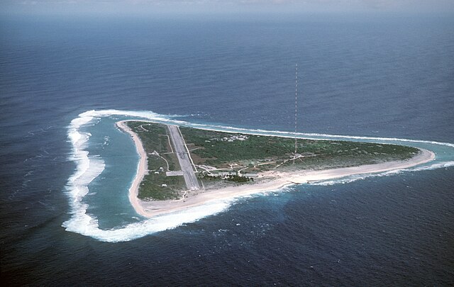
English: Aerial view of Minamitori Island (Minami-Torishima), Japan. There is a runway which supported the US Coast Guard station located there prior to 1993. Minamitori Island is the easternmost island of the Japanese archipelago.
Deutsch: Luftaufnahme der Minamitori Insel (Minami-Torishima), Japan.
日本語: 南鳥島の空中写真。 |
|||
| Dată | ||||
| Sursă |
|
|||
| Autor | Chief Master Sergeant Don Sutherland, U.S. Air Force |
Licențiere
Această imagine este o lucrare a unui angajat fie al Armatei Americane, fie al Departamentului de Apărare, ce a fost realizată în timp ce acesta își exercita îndatoririle oficiale. Fiind o lucrare a guvernului federal al Statelor Unite, imaginea este în domeniul public.
Vedeți http://www.defenselink.mil/multimedia/about.html.
|
 |
Istoricul fișierului
Apăsați pe Data și ora pentru a vedea versiunea trimisă atunci.
| Data și ora | Miniatură | Dimensiuni | Utilizator | Comentariu | |
|---|---|---|---|---|---|
| actuală | 18 ianuarie 2007 04:38 | | 2.824x1.789 (1,09 MB) | Balcer~commonswiki | ID: DFST8708298 Service Depicted: Coalition or Allied Forces Aerial view of Marcus Island and the runway which supports the US Coast Guard station located there. Marcus Island is the southernmost island in the Japanese chain. Camera Operator: CMSGT |
Utilizarea fișierului
Următoarele pagini conțin această imagine:
Utilizarea globală a fișierului
Următoarele alte proiecte wiki folosesc acest fișier:
- Utilizare la ar.wikipedia.org
- Utilizare la ast.wikipedia.org
- Utilizare la az.wikipedia.org
- Utilizare la be.wikipedia.org
- Utilizare la ca.wikipedia.org
- Utilizare la ceb.wikipedia.org
- Utilizare la cs.wikipedia.org
- Utilizare la de.wikipedia.org
- Utilizare la el.wikipedia.org
- Utilizare la en.wikipedia.org
- Utilizare la es.wikipedia.org
- Utilizare la et.wikipedia.org
- Utilizare la eu.wikipedia.org
- Utilizare la fa.wikipedia.org
- Utilizare la fi.wikipedia.org
- Utilizare la frr.wikipedia.org
- Utilizare la fr.wikipedia.org
- Utilizare la fr.wiktionary.org
- Utilizare la gl.wikipedia.org
- Utilizare la hy.wikipedia.org
- Utilizare la it.wikipedia.org
- Utilizare la ja.wikipedia.org
Vizualizați utilizările globale ale acestui fișier.