Fișier:British Empire Anachronous 7.png
Mărimea acestei previzualizări: 800 × 370 pixeli. Alte rezoluții: 320 × 148 pixeli | 640 × 296 pixeli | 1.357 × 628 pixeli.
Mărește rezoluția imaginii (1.357 × 628 pixeli, mărime fișier: 48 KB, tip MIME: image/png)
| Acest fișier se află la Wikimedia Commons. Consultați pagina sa descriptivă acolo. |
Descriere fișier

|
Imaginile din această galerie trebuie recreat(ă/e) sub format vectorial ca fișier SVG. Acest format are mai multe avantaje; vezi Commons:Media for cleanup pentru mai multe informații. Dacă deja este disponibilă o versiune SVG a acestei imagini, vă rugăm să o încărcați. După încărcarea pe serverele Commons a versiunii SVG, înlocuiți acest format cu formatul {{vector version available|noul nume al imaginii.svg}}.
|

|
Acest fișier a fost înlocuit cu File:The British Empire.png. Se recomandă folosirea celuilalt fișier. Notă: Acest fișier nu va fi șters decât prin cererea explicită în cadrul nominalizărilor pentru ștergere.
|
| Descriere |
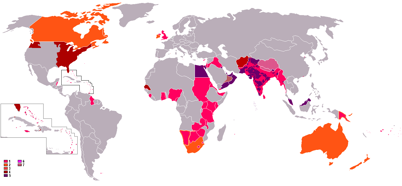
English: : An anachronous map of the British Empire (showing its many forms of control). The colours in the map key are explained according to their related numbers as follows:
|
| Dată | 8 octombrie 2006 (original upload date) |
| Sursă | Transferred from en.wikipedia to Commons. |
| Autor | The original uploader was Gsd2000 at engleză Wikipedia. |
Licențiere

|
Se permite copierea, distribuirea și/sau modificarea acestui document conform termenilor Documentației de licență liberă GNU, versiunea 1.2 sau orice altă versiune ulterioară publicată de Free Software Foundation, fără părți neschimbabile, texte de pe copertele principale și finale. O copie a acestei licențe este inclusă în secțiunea numită Documentația de licență liberă GNU. |
| Acest fișier a fost eliberat sub licența Creative Commons Atribuire și distribuire în condiții identice 3.0 Neadaptată. | ||
| ||
| Această licență a fost atașată fișierului ca parte a actualizării licențierilor GFDL. |
Jurnalul original al încărcărilor
Pagina originală de descriere a fost aici. Toate numele de utilizator de mai jos sunt pentru en.wikipedia.
- 2006-10-08 13:08 Gsd2000 1357×628×8 (42019 bytes)
Istoricul fișierului
Apăsați pe Data și ora pentru a vedea versiunea trimisă atunci.
| Data și ora | Miniatură | Dimensiuni | Utilizator | Comentariu | |
|---|---|---|---|---|---|
| actuală | 8 noiembrie 2021 02:41 | | 1.357x628 (48 KB) | Randomastwritter | jubaland |
| 31 octombrie 2021 11:04 |  | 1.357x628 (48 KB) | Randomastwritter | . | |
| 13 iunie 2009 22:47 |  | 1.357x628 (41 KB) | Mnmazur | Reverted to version as of 20:37, 20 September 2007 - Spheres of influnce extended beyond Tibet but did not cover the entire country. Firthermore, even if they had, that map uses current Chinese borders and therefore filling in the country just doesn't wo | |
| 18 aprilie 2008 16:01 |  | 1.357x628 (55 KB) | LaGrandefr~commonswiki | {{Information |Description= {{en}}: An anachronous map of the British Empire (showing its many forms of control). The colours in the map key are explained according to their related numbers as follows: *1.Pink: colonies held by 1945 *2.Orange:Dominions | |
| 20 septembrie 2007 23:37 |  | 1.357x628 (41 KB) | Tarret | {{Information |Description=An anachronous map of the British Empire (showing its many forms of control). The colours in the map key are explained according to their related numbers as follows: *1.Pink: colonies held by 1945 *2.Orange:Dominions *3.Pink in |
Utilizarea fișierului
Următoarele pagini conțin această imagine:
Utilizarea globală a fișierului
Următoarele alte proiecte wiki folosesc acest fișier:
- Utilizare la cs.wikipedia.org
- Utilizare la th.wikipedia.org