Fișier:Great Basin map.gif

Mărimea acestei previzualizări: 537 × 600 pixeli. Alte rezoluții: 215 × 240 pixeli | 430 × 480 pixeli | 687 × 768 pixeli | 1.074 × 1.200 pixeli.
Mărește rezoluția imaginii (1.074 × 1.200 pixeli, mărime fișier: 342 KB, tip MIME: image/gif, 0,1 s)
| Acest fișier se află la Wikimedia Commons. Consultați pagina sa descriptivă acolo. |
Descriere fișier
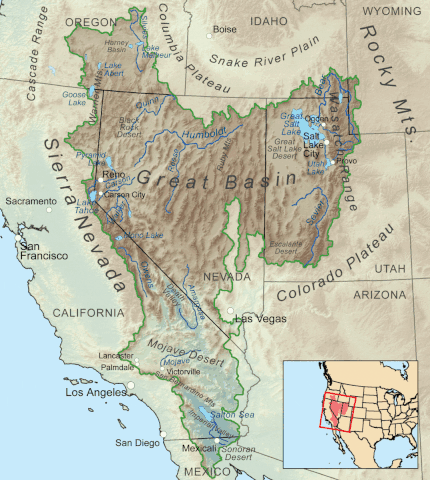
| Descriere | Map showing the Great Basin drainage basin as defined hydrologically. |
| Dată | (UTC) |
| Sursă |
This file was derived from: Greatbasinmap.png:  |
| Autor |
|
Licențiere
Kmusser at Wikimedia Commons, deținătorul drepturilor de autor ale acestei opere, prin prezenta își publică lucrarea sub următoarea licență:
Acest fișier a fost eliberat sub licența Creative Commons Atribuire și distribuire în condiții identice 3.0 Neadaptată.
Atribuire: Kmusser at Wikimedia Commons
- Sunteți liber:
- să partajați cu alții – aveți dreptul de a copia, distribui și transmite opera
- să adaptați – aveți dreptul de a adapta opera
- În următoarele condiții:
- atribuind – Trebuie să atribuiți opera corespunzător, introducând o legătură către licență și indicând dacă ați făcut schimbări. Puteți face asta prin orice metodă rezonabilă, dar nu într-un fel care ar sugera faptul că persoana ce a licențiat conținutul v-ar susține sau ar aproba folosirea de către dumneavoastră a operei sale.
- partajând în condiții identice – Dacă modificați, transformați sau creați pe baza acestei opere, trebuie să distribuiți opera rezultată doar sub aceeași licență sau sub o licență similară acesteia.
Jurnalul original al încărcărilor
This image is a derivative work of the following images:
- File:Greatbasinmap.png licensed with Cc-by-sa-3.0
- 2020-09-04T22:25:15Z Nwbeeson 1500x1676 (7565343 Bytes) Added boundary map. Second attempt to upload the image.
- 2020-09-04T22:21:06Z Nwbeeson 1500x1676 (7564895 Bytes) Added boundary line.
- 2010-12-11T16:58:55Z Kmusser 1500x1676 (3820728 Bytes) Added Goose Lake
- 2010-11-17T20:37:07Z Kmusser 1500x1676 (3382394 Bytes) == Summary == {{Information |Description=Map showing the [[:w:Great Basin|Great Basin]] drainage basin as defined hydrologically. |Source={{own}}, Elevation data from [[:w:Shuttle Radar Topography Mission|SRTM]], all other fe
Uploaded with derivativeFX
Istoricul fișierului
Apăsați pe Data și ora pentru a vedea versiunea trimisă atunci.
| Data și ora | Miniatură | Dimensiuni | Utilizator | Comentariu | |
|---|---|---|---|---|---|
| actuală | 8 mai 2022 01:05 | | 1.074x1.200 (342 KB) | Hike395 | == {{int:filedesc}} == {{Information |Description=Map showing the Great Basin drainage basin as defined hydrologically. |Source={{Derived from|Greatbasinmap.png|display=50}} |Date=2022-05-07 22:03 (UTC) |Author=* File:Greatbasinmap.png: Kmusser * conversion to gif: [[User:{{subst:REVISIONUSER}}|{{subst:REVISIONUSER}}]] |Permission= |other_versions= }} == {{int:license-header}} == {{self|author={{user at project|Kmusser|c}}|Cc-by... |
Utilizarea fișierului
Următoarele pagini conțin această imagine:
Utilizarea globală a fișierului
Următoarele alte proiecte wiki folosesc acest fișier:
- Utilizare la en.wikipedia.org
- List of rivers of the Americas
- Great Basin
- Rain shadow
- Geology of the United States
- List of rivers of the Great Basin
- Bear River (Great Salt Lake)
- Talk:Great Basin
- Weber River
- List of deserts by area
- Fish Lake Valley
- Dixie Valley
- List of Great Basin watersheds
- Template:Great Basin watersheds
- Great Basin Divide
- Antelope Valley (Eureka County)
- Indian Springs Pass
- Antelope Valley (southwest Millard County, Utah)
- User:Mmcannis/sandbox/McCullough Range south Triple Point (water divide)
- User:Mmcannis/sandbox/Original-New York Mountains north divide
- User:Mmcannis/sandbox/Indian Springs Pass
- Numaga
- Utilizare la fi.wikipedia.org
- Utilizare la hy.wikipedia.org
- Utilizare la si.wikipedia.org
- Utilizare la www.wikidata.org