Fișier:Tet-Offensive-Map.jpg
Rezoluții mai mari nu sunt disponibile.
Tet-Offensive-Map.jpg (330 × 448 pixeli, mărime fișier: 21 KB, tip MIME: image/jpeg)
| Acest fișier se află la Wikimedia Commons. Consultați pagina sa descriptivă acolo. |
Descriere fișier

|
Imaginile din această galerie trebuie recreat(ă/e) sub format vectorial ca fișier SVG. Acest format are mai multe avantaje; vezi Commons:Media for cleanup pentru mai multe informații. Dacă deja este disponibilă o versiune SVG a acestei imagini, vă rugăm să o încărcați. După încărcarea pe serverele Commons a versiunii SVG, înlocuiți acest format cu formatul {{vector version available|noul nume al imaginii.svg}}.
|


|
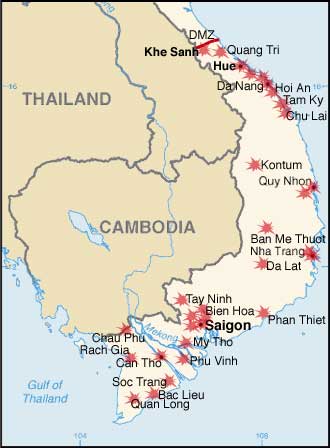
This map has been uploaded by Electionworld from en.wikipedia.org to enable the |
Modified by me from a CIA Factbook map.
Map showing the major targets of the Tet Offensive January-February, 1968
Licențiere
This image is in the public domain because it contains materials that originally came from the United States Central Intelligence Agency's World Factbook.
|
 |
Istoricul fișierului
Apăsați pe Data și ora pentru a vedea versiunea trimisă atunci.
| Data și ora | Miniatură | Dimensiuni | Utilizator | Comentariu | |
|---|---|---|---|---|---|
| actuală | 8 decembrie 2006 00:34 | | 330x448 (21 KB) | Electionworld | {{ew|en|KarlBunker}} Modified by me from a CIA Factbook map. Map showing the major targets of the Tet Offensive January-February, 1968 == Licensing == {{PD-USGov-CIA-WF}} |
Utilizarea fișierului
Următoarele pagini conțin această imagine:
Utilizarea globală a fișierului
Următoarele alte proiecte wiki folosesc acest fișier:
- Utilizare la ca.wikipedia.org
- Utilizare la da.wikipedia.org
- Utilizare la en.wikipedia.org
- Utilizare la eo.wikipedia.org
- Utilizare la fi.wikipedia.org
- Utilizare la fr.wikipedia.org
- Utilizare la he.wikipedia.org
- Utilizare la nl.wikipedia.org
- Utilizare la no.wikipedia.org
- Utilizare la pl.wikipedia.org
- Utilizare la pl.wikibooks.org
- Utilizare la sh.wikipedia.org
- Utilizare la simple.wikipedia.org
- Utilizare la sk.wikipedia.org
- Utilizare la vi.wikipedia.org