Fișier:The Man in the High Castle Plausible World Map.png
Mărimea acestei previzualizări: 800 × 579 pixeli. Alte rezoluții: 320 × 232 pixeli | 640 × 463 pixeli | 1.024 × 741 pixeli | 1.280 × 926 pixeli | 1.577 × 1.141 pixeli.
Mărește rezoluția imaginii (1.577 × 1.141 pixeli, mărime fișier: 400 KB, tip MIME: image/png)
| Acest fișier se află la Wikimedia Commons. Consultați pagina sa descriptivă acolo. |

|
This map, as well as other fictitious maps, is fictitious or too incorrect (i.e. due to anachronism) to be used in real-life contexts (contemporary or historic). It may have some visual elements that are similar to official maps such as colors or certain layout features, but they are NOT official and don't have any official recognition. |
[[Category:]]
Descriere fișier
| Descriere |
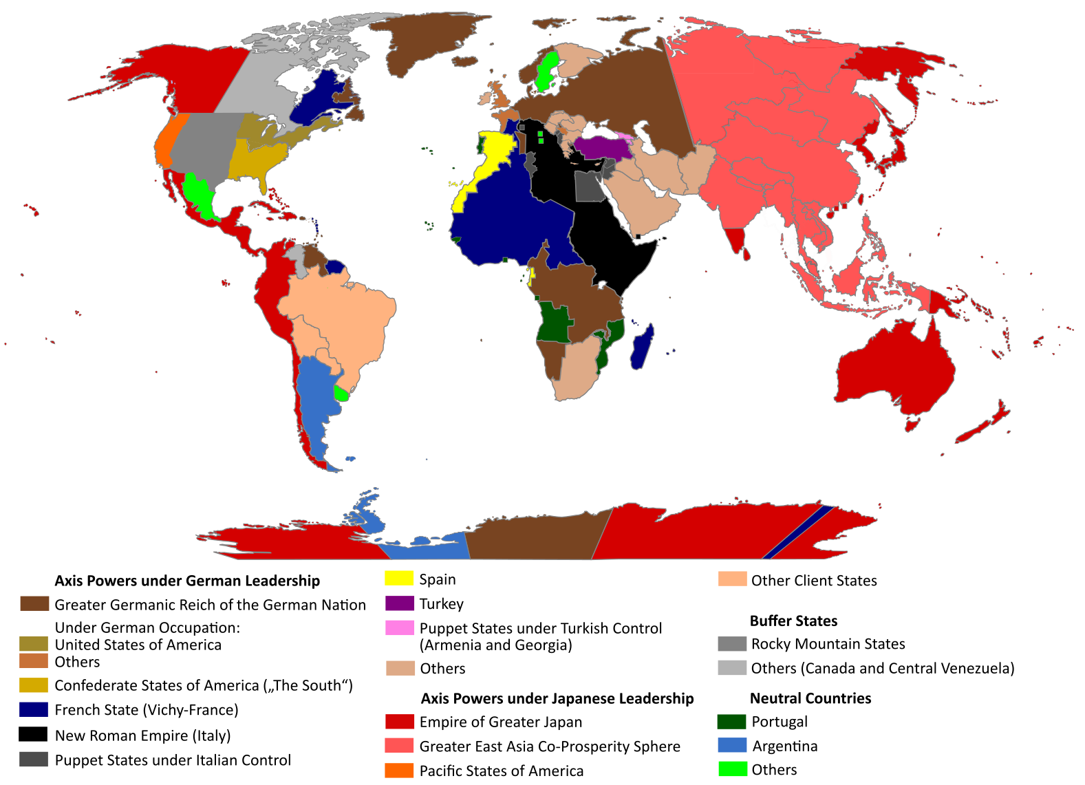
English: "The Man in the High Castle" is an alternate history novel by Philip K. Dick. It is set in a world in which the Axis powers have won World War II. This map is inspired by Dick's story and shows a plausible division of the world between Nazi Germany (dark brown), Imperial Japan (dark red) and their respective allies. However, the map is much more precise than the book describes.
https://web.archive.org/web/20191202005150/http://www.high-castle-world-map.com:80/ |
| Dată | |
| Sursă | Operă proprie |
| Autor | RobintheHighCastle |
| Permisiune (Reutilizarea acestui fișier) |
Licențiere
Eu, deținătorul drepturilor de autor ale acestei opere, prin prezenta îmi public lucrarea sub următoarea licență:
Acest fișier a fost eliberat sub licența Creative Commons Atribuire și distribuire în condiții identice 4.0 Internațională.
- Sunteți liber:
- să partajați cu alții – aveți dreptul de a copia, distribui și transmite opera
- să adaptați – aveți dreptul de a adapta opera
- În următoarele condiții:
- atribuind – Trebuie să atribuiți opera corespunzător, introducând o legătură către licență și indicând dacă ați făcut schimbări. Puteți face asta prin orice metodă rezonabilă, dar nu într-un fel care ar sugera faptul că persoana ce a licențiat conținutul v-ar susține sau ar aproba folosirea de către dumneavoastră a operei sale.
- partajând în condiții identice – Dacă modificați, transformați sau creați pe baza acestei opere, trebuie să distribuiți opera rezultată doar sub aceeași licență sau sub o licență similară acesteia.
Istoricul fișierului
Apăsați pe Data și ora pentru a vedea versiunea trimisă atunci.
| Data și ora | Miniatură | Dimensiuni | Utilizator | Comentariu | |
|---|---|---|---|---|---|
| actuală | 29 octombrie 2021 17:55 | | 1.577x1.141 (400 KB) | Saltner67 | Added the portoguese colonies Cabinda and Ajuda since they would still have existed in this world. |
| 20 iunie 2021 11:05 |  | 1.613x1.143 (417 KB) | Gernsback67 | Changed "Greater Asian Co-Prosperity Sphere" in "Greater East Asia Co-Prosperity Sphere", which is correct. | |
| 16 octombrie 2020 18:30 |  | 1.611x1.138 (418 KB) | Saltner67 | Restored the latest version. Please do not revert any changes, which have been made to this file so far, without any communication with the author of the map. All changes made here have been initialized by the author and are a result of the same process which has led to the creation of the map in the first place. | |
| 16 octombrie 2020 11:25 |  | 1.621x1.137 (392 KB) | Gooduserdude | RV Original research: this image is based on a source and should not be altered | |
| 29 martie 2020 17:15 |  | 1.611x1.138 (418 KB) | Saltner67 | Improved the accuracy of borders of Mongolia and Manchukuo. | |
| 27 martie 2020 18:58 |  | 1.607x1.138 (418 KB) | Saltner67 | Enlarged Manchukuo and added the puppet states of Yakutia and Krasnoyarsk/Irkutsk after more research on Kantokuen. | |
| 12 martie 2020 22:07 |  | 1.612x1.143 (411 KB) | Saltner67 | Moved the Swiss Canton of Valais from Germany to Italy, as has been prepared in the plans for Operation Tannenbaum. | |
| 8 februarie 2020 21:57 |  | 1.605x1.139 (411 KB) | Saltner67 | Reinserted the territories of Tunisia,Greece, Crete and Cyprus after research on the Italian plannings and Greece in WWII. | |
| 21 noiembrie 2019 16:21 |  | 1.611x1.133 (409 KB) | Gernsback67 | Enlarged Mongolia again after more research on pan-mongolism. | |
| 21 septembrie 2019 18:13 |  | 1.610x1.137 (408 KB) | Saltner67 | unified Mongolia, enlarged Manchukuo and Thailand, re-inserted the real-life borders of Laos and Vietnam after research on Demchugdongrub, Kantokuen, Thailand and Indochina in WWII |
Utilizarea fișierului
Următoarele pagini conțin această imagine:
Utilizarea globală a fișierului
Următoarele alte proiecte wiki folosesc acest fișier:
- Utilizare la ar.wikipedia.org
- Utilizare la cs.wikipedia.org
- Utilizare la da.wikipedia.org
- Utilizare la de.wikipedia.org
- Utilizare la en.wikipedia.org
- Utilizare la en.wikiquote.org
- Utilizare la es.wikipedia.org
- Utilizare la gl.wikipedia.org
- Utilizare la he.wikipedia.org
- Utilizare la hu.wikipedia.org
- Utilizare la it.wikipedia.org
- Utilizare la ja.wikipedia.org
- Utilizare la ko.wikipedia.org
- Utilizare la lt.wikipedia.org
- Utilizare la nl.wikipedia.org
- Utilizare la pl.wikipedia.org
- Utilizare la pt.wikipedia.org
- Utilizare la ru.wikipedia.org
- Utilizare la th.wikipedia.org
- Utilizare la uk.wikipedia.org
- Utilizare la zh-classical.wikipedia.org
- Utilizare la zh.wikipedia.org