Districtul Hat Yai
district din Thailanda
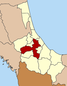
Hat Yai (în thailandeză หาดใหญ่) este un district (Amphoe) din provincia Songkhla, Thailanda, cu o populație de 384.994 de locuitori și o suprafață de 852,796 km².
| Hat Yai | |
| หาดใหญ่ | |
| — Amphoe — | |
 | |
| Poziția geografică | |
| Coordonate: 7°0′7″N 100°27′26″E / 7.00194°N 100.45722°E | |
|---|---|
| Țară | |
| Provincie | Songkhla |
| Reședință | |
| Geocod | 9011 |
| Suprafață | |
| - Total | 852,796 km² |
| Altitudine | 11 m.d.m. |
| Populație (2013) | |
| - Total | 384.994 locuitori |
| - Densitate | 451 loc./km² |
| Fus orar | THA (+7) |
| Cod poștal | 90110 |
| Prezență online | |
| GeoNames | |
 | |
| Modifică date / text | |
Componență
modificareDistrictul este subdivizat în 13 subdistricte (tambon), care sunt subdivizate în 98 de sate (muban).
| Nr. | Nume | În thailandeză | Sate | Locuitori | |
|---|---|---|---|---|---|
| 1. | Hat Yai | หาดใหญ่ | - | 158,412 | |
| 2. | Khuan Lang | ควนลัง | 6 | 42,266 | |
| 3. | Khu Tao | คูเต่า | 10 | 11,015 | |
| 4. | Kho Hong | คอหงส์ | 8 | 44,916 | |
| 5. | Khlong Hae | คลองแห | 11 | 32,553 | |
| 7. | Khlong U Taphao | คลองอู่ตะเภา | 4 | 2,820 | |
| 8. | Chalung | ฉลุง | 6 | 7,285 | |
| 11. | Thung Yai | ทุ่งใหญ่ | 6 | 5,131 | |
| 12. | Thung Tam Sao | ทุ่งตำเสา | 10 | 16,053 | |
| 13. | Tha Kham | ท่าข้าม | 8 | 7,933 | |
| 14. | Nam Noi | น้ำน้อย | 10 | 13,470 | |
| 16. | Ban Phru | บ้านพรุ | 11 | 29,610 | |
| 18. | Phatong | พะตง | 8 | 13,530 |
